Australian Politics Forum
http://www.ozpolitic.com/forum/YaBB.pl
Member Run Boards >> Environment >> Why satellites cannot measure sea level..??
http://www.ozpolitic.com/forum/YaBB.pl?num=1377845110

Message started by Ajax on Aug 30th, 2013 at 4:45pm

Title: Why satellites cannot measure sea level..??
Post by Ajax on Aug 30th, 2013 at 4:45pm
Professor Willie Soon discusses why satellites can't do the job

http://youtu.be/1gmW9GEUYvA

Tide gauges are a good check on satellite data.

http://youtu.be/8EMoU8OOsBs

Title: Re: Why satellites cannot measure sea level..??
Post by Ajax on Aug 31st, 2013 at 10:01am
No response lads....??????

Title: Re: Why satellites cannot measure sea level..??
Post by # on Aug 31st, 2013 at 3:59pm

Ajax wrote on Aug 31st, 2013 at 10:01am:
No response lads....??????

The toddler persistently demands attention. After a while, the adults stop paying it.

Title: Re: Why satellites cannot measure sea level..??
Post by Ajax on Aug 31st, 2013 at 5:36pm

# wrote on Aug 31st, 2013 at 3:59pm:

Ajax wrote on Aug 31st, 2013 at 10:01am:
No response lads....??????

The toddler persistently demands attention. After a while, the adults stop paying it.


If you have nothing to say...best not say anything... :-*

Title: Re: Why satellites cannot measure sea level..??
Post by muso on Aug 31st, 2013 at 6:52pm
Willy Soon is an Astronomer (Astrophysicist). He comments on just about every discipline apart from his own, and that includes Polar Bear distributions and Sea Level.  He is well paid by the Heartland Institute, who in turn are paid by coal and oil companies. He has never actually published anything on Sea Level, and his little party piece doesn't come from a position of understanding the technology or performing some kind of statistical analysis. Nothing so technical, and no actual paper.

Willie Soon's own words on his methodology:


Quote:
Over Christmas I happen to ah, all the dots and everything fall into places


I've already given you the information on the Swedish chef, or retired Geology Associate professor.

He was even embarassing himself in the late 90s boasting about his magical powers.
http://www.mindspring.com/~anson/randi-hotline/1998/0012.html


Quote:
LOOKING IN ON SWEDEN

I've described here previously how a pompous-assed "dowsing expert" named Nils-Axel Morner, associate professor of geology from Stockholm University, has consistently refused to be tested for the Pigasus Prize. A helpful correspondent in Sweden referred me to
http://www.tdb.uu.se/~karl/dowsing/ where I found that Morner was tested -- amateurishly -- on a prominent Swedish TV show, "The Plain & Simple Truth," on TV2 on February 27th. Morner was first provided the opportunity to brag about anecdotal successes, then he was tested. A local celebrity -- a singer -- was involved, as is usual with these drearily predictable affairs. The singer chose one of ten cups under which to conceal a packet of sugar. He chose number seven; are we surprised? Morner had designed this test, saying that it was especially difficult for him to do. (???) He said that water or metal could be located "right away," but not sugar.

Title: Re: Why satellites cannot measure sea level..??
Post by # on Aug 31st, 2013 at 9:31pm

Ajax wrote on Aug 31st, 2013 at 5:36pm:
...
If you have nothing to say...best not say anything... :-*

OK, child. Of Willie Soon, Sourcewatch says
Quote:
Dr. Willie Wei-Hock Soon (who is most commonly referred to as Willie Soon) is a global warming skeptic. He is a physicist at the Solar, Stellar, and Planetary Sciences Division of the Harvard-Smithsonian Center for Astrophysics and, since 1992[1], has been an astronomer at the Mount Wilson Observatory,[2], where climate denier and Marshall Institute co-founder Robert Jastrow was Director[3] from 1992-2003.[4]

"U.S. oil and coal companies, including ExxonMobil, the American Petroleum Institute, Koch Industries, and the world’s largest coal-burning utility, Southern Company, have contributed more than $1 million over the past decade to his research. According to Greenpeace, every grant Dr. Soon has received since 2002 has been from oil or coal interests."[5]
...
Biographical notes

A biographical note formerly on the website of DCI Group-run Tech Central Station, where Soon was listed as "Science Director" between approximately September 2003[6] and May 2007, listed his "areas of Expertise" as "Global warming", "Mercury", "Solar Variability" and the "Arctic".[7] His bio note on TCS stated that "Dr. Willie Soon's views expressed are not necessarily those of the Harvard-Smithsonian Center for Astrophysics."[7]

A biographical note from 2000 stated that he was "a contributing editor to World Climate Report and member of the American Astrophysical Society, American Geophysical Union, and International Astronomical Union."[8] Two years later, another biographical note stated that he was a former contributing editor to World Climate Report but added that he was then an "Adjunct Professor of the Faculty of Science and Environmental Studies of the University of Putra, Malaysia." It also stated that "for years, he has researched the topic of the orbital theory of climate change, the Milankovic theory for glacial and interglacial changes."[9]

Global Warming Skeptic ties

Soon has long been associated with various U.S. and Canadian think tanks disputing human-induced global warming. Many of the papers he has published on the topic have been co-authored with Sallie L. Baliunas and sometimes with her and other co-authors.

Between December 1998[10] and September 2001[11] he was listed as a "Scientific Adviser" to the Greening Earth Society, a group that was funded and controlled by the Western Fuels Association (WFA), an association of coal-burning utility companies. WFA founded the group in 1997, according to an archived version of its website, "as a vehicle for advocacy on climate change, the environmental impact of CO2, and fossil fuel use."[12] While Soon remains listed on the websites of various think tanks noted for disputing global warming -- such as the Fraser Institute in Canada and the George C. Marshall Institute in the U.S. -- Soon has not written for them for a long time. (For example, the last paper by Soon published on the website of the Fraser Institute dates back to January 2003[13] and for the Marshall Institute the last published paper was in May 2003[14]) (Baliunas was one of the other "scientific advisers").

As of early 2009, Soon's current biographical note states that he "is chief science adviser for the Science and Public Policy Institute".[15] Prior to Bob Ferguson founding SPPI in mid 2007, Soon worked with him from mid-2003 at the Center for Science and Public Policy, a project of Frontiers of Freedom (FOF)[16] funded, at least in part, by Exxon.[17]

The site's use of the term "skeptic" in relation to this character is overly generous.

According to DeSmogBlog
Quote:
Soon is a prominent climate change skeptic who has received much of his research funding from the oil and gas industry.

According to David Suzuki:

[quote]"U.S. oil and coal companies, including ExxonMobil, the American Petroleum Institute, Koch Industries, and the world’s largest coal-burning utility, Southern Company, have contributed more than $1 million over the past decade to his research. According to Greenpeace, every grant Dr. Soon has received since 2002 has been from oil or coal interests."
[/quote]
With so many ties to the rabid Right and fossil fuel industry, his credibility I would charitably put at nil.

Ajax, do you deliberately choose such risible sources?

Title: Re: Why satellites cannot measure sea level..??
Post by muso on Aug 31st, 2013 at 9:44pm
By the way, Ajax,  that Soon and Baliunas (2003) paper that you quoted is the only paper that has ever led to the resignation of 6 editors in protest at the failure of peer-review that led to its publication. Google the "Soon and Baliunas controversy".

The paper was repudiated by the publisher.

Quote:
Why satellites cannot measure sea level..??


The experts in Sea Level - University of Colorado Sea Level Unit differ on that. Willie Soon has obviously taken some time off manipulating Polar Bear distribution data to "oh ah connect the dots" but just about every oceanographer adopts a more methodical approach.   It's an accepted standard methodology. If you look at the graph of Sea Level that I posted 6 times, you'll find the link.

Title: Re: Why satellites cannot measure sea level..??
Post by Ajax on Sep 1st, 2013 at 10:35am
Typical AGW religious reactions, shoot the messenger.

You don't need to be a rocket scientist, if the frequency can only work within 100mm or so how can it be expected to be accurate to 3mm.....???????

Not to mention cloud cover and wind and water vapour and even solar radiation.

As usual pissing against the wind boys..................???

Title: Re: Why satellites cannot measure sea level..??
Post by # on Sep 1st, 2013 at 9:03pm

Ajax wrote on Sep 1st, 2013 at 10:35am:
...
You don't need to be a rocket scientist, ...
But it helps to be literate, numerate and of at least average intelligence.

Title: Re: Why satellites cannot measure sea level..??
Post by Ajax on Sep 2nd, 2013 at 1:56pm

# wrote on Sep 1st, 2013 at 9:03pm:

Ajax wrote on Sep 1st, 2013 at 10:35am:
...
You don't need to be a rocket scientist, ...
But it helps to be literate, numerate and of at least average intelligence.


At least I don't follow a religion because they scream out "because I said so", dude I want to see proof.

And so far the computer circulation models have just shown us how unreliable they really are.

If this was 50 years ago, there is enough evidence now to throw the AGW hypothesis in the rubbish bin where it belongs.

Title: Re: Why satellites cannot measure sea level..??
Post by muso on Sep 2nd, 2013 at 8:25pm

Ajax wrote on Sep 1st, 2013 at 10:35am:
Typical AGW religious reactions, shoot the messenger.

You don't need to be a rocket scientist, if the frequency can only work within 100mm or so how can it be expected to be accurate to 3mm.....???????

Not to mention cloud cover and wind and water vapour and even solar radiation.

As usual pissing against the wind boys..................???


I have no idea what you're talking about. Can anybody interpret?

As for shooting the messenger,  here is Willie Soon's stated methodology again:

Quote:
Over Christmas I happen to ah, all the dots and everything fall into places 


It's worth watching Willie Soon's video just for that gem alone.

Title: Re: Why satellites cannot measure sea level..??
Post by Rider on Sep 2nd, 2013 at 8:34pm
Ajax have you read this?

http://notrickszone.com/2013/08/30/university-of-colorado-admits-radar-altimetry-is-pretty-much-useless-for-measuring-sea-level/

Satellite Measured Sea Level Is Measuring Ocean Heat By Ed Caryl

Sometime in the last year, someone commented in some article that sea level rise as observed by satellite radar altimetry was overstated due to the fact that as warm water expands, it gets lighter, gravity has less pull on it, and it bulges up. Since then, a couple of global maps have come to my attention.

see link for the rest....Muso and friends, no need to follow this link, it will only offend your religious zeal.

Title: Re: Why satellites cannot measure sea level..??
Post by muso on Sep 2nd, 2013 at 8:51pm
What about Tide gauges? Are they subject to the same issue?


Quote:
Since 1993, measurements from the TOPEX and Jason series of satellite radar altimeters have allowed estimates of global mean sea level. These measurements are continuously calibrated against a network of tide gauges.

University of Colorado

Rider:

Quote:
Sometime in the last year, someone commented in some article that sea level rise as observed by satellite radar altimetry was overstated due to the fact that as warm water expands, it gets lighter, gravity has less pull on it, and it bulges up.


So you agree that the oceans are  getting warmer? Can you explain that to Ajax please, because he keeps on saying that there has been no warming?

So let's see.. the water bulges up... the sea level rises but it's not really a rise, it's just heat.  So you can't drown in it because where the seawater bulges up is actually phantom water. 

So that graph is actually a graph of increasing vertical bulge as opposed to rising sea level?

Who is this  Ed Caryl anyway? English grammar doesn't seem to be his strong point. He's not very good with logical argument. How's his arithmetic? Just a hunch. He reminds me of someone.


Title: Re: Why satellites cannot measure sea level..??
Post by # on Sep 3rd, 2013 at 2:31pm

Rider wrote on Sep 2nd, 2013 at 8:34pm:
Ajax have you read this?

http://notrickszone.com/2013/08/30/university-of-colorado-admits-radar-altimetry-is-pretty-much-useless-for-measuring-sea-level/

Satellite Measured Sea Level Is Measuring Ocean Heat By Ed Caryl
...

The only reference I could find to Ed Caryl, outside the denyosphere is this one from Wott's Up With That?
Quote:
... the analysis is by Pierre Gosselin’s ”guest author” Ed Caryl, whose credentials seem limited to being a balding white male who likes to parrot that Antarctic ice is expanding. But that’s better than most of Anthony’s esteemed sources.
So he's apparently well-regarded in the denyosphere, but totally unqualified. The article in question is on No Tricks Zone, which pretty much says it all.

Title: Re: Why satellites cannot measure sea level..??
Post by Rider on Sep 3rd, 2013 at 3:25pm

# wrote on Sep 3rd, 2013 at 2:31pm:

Rider wrote on Sep 2nd, 2013 at 8:34pm:
Ajax have you read this?

http://notrickszone.com/2013/08/30/university-of-colorado-admits-radar-altimetry-is-pretty-much-useless-for-measuring-sea-level/

Satellite Measured Sea Level Is Measuring Ocean Heat By Ed Caryl
...

The only reference I could find to Ed Caryl, outside the denyosphere is this one from Wott's Up With That?
Quote:
... the analysis is by Pierre Gosselin’s ”guest author” Ed Caryl, whose credentials seem limited to being a balding white male who likes to parrot that Antarctic ice is expanding. But that’s better than most of Anthony’s esteemed sources.
So he's apparently well-regarded in the denyosphere, but totally unqualified. The article in question is on No Tricks Zone, which pretty much says it all.


Did you get a special prize for being a good student at the Saul Alinsky College for Deadsh1ts?

* RULE 12: Pick the target, freeze it, personalize it, and polarize it.” Cut off the support network and isolate the target from sympathy. Go after people and not institutions; people hurt faster than institutions. (This is cruel, but very effective. Direct, personalized criticism and ridicule works.)


Title: Re: Why satellites cannot measure sea level..??
Post by Ajax on Sep 3rd, 2013 at 4:22pm

Rider wrote on Sep 2nd, 2013 at 8:34pm:
Ajax have you read this?

http://notrickszone.com/2013/08/30/university-of-colorado-admits-radar-altimetry-is-pretty-much-useless-for-measuring-sea-level/

Satellite Measured Sea Level Is Measuring Ocean Heat By Ed Caryl

Sometime in the last year, someone commented in some article that sea level rise as observed by satellite radar altimetry was overstated due to the fact that as warm water expands, it gets lighter, gravity has less pull on it, and it bulges up. Since then, a couple of global maps have come to my attention.

see link for the rest....Muso and friends, no need to follow this link, it will only offend your religious zeal.


Hi Rider,

Hey dude i'm realizing really fast that these alarmists on here don't want to debate, but rather PUSH the AGW religion on to the forumites that frequent here.

They rubbish the data and when they cant do that they rubbish the presenter.

Any decent human being that reads the criticism of why satellites cannot measure sea level properly will understand.

These guys don't want to understand they already know, all they want to do is push the AGW agenda.


Quote:
University Of Colorado Radar Altimetry Is Pretty Much Useless For Measuring Sea Level

Satellite Measured Sea Level Is Measuring Ocean Heat
By Ed Caryl

Sometime in the last year, someone commented in some article that sea level rise as observed by satellite radar altimetry was overstated due to the fact that as warm water expands, it gets lighter, gravity has less pull on it, and it bulges up. Since then, a couple of global maps have come to my attention. First, a map of sea level rise.

Read the rest here
http://notrickszone.com/2013/08/30/university-of-colorado-admits-radar-altimetry-is-pretty-much-useless-for-measuring-sea-level/

Title: Re: Why satellites cannot measure sea level..??
Post by muso on Sep 3rd, 2013 at 4:33pm
So if you two geniuses agree with this "paper", could you please explain to me what the difference is between "bulging  up" and "rising".

Does he means that it's bulging up like a helium balloon or what?


Quote:
gravity has less pull on it, and it bulges up


How exactly does that bit work? Go on. If you believe it, explain it.

Ajax - does this mean that you now believe that the ocean is heating?

These replies are going to be very entertaining. :)

So far, we've established from this article that the ocean is heating and rising sorry bulging upwards. Is that a fair assessment?

I can see that he is meticulous with his citations too:


Quote:
someone commented in some article


;D ;D ;D ;D
Figure 1: Gradually increasing Bulging up tendency of the Oceans.


Just remind me what the confidence level of "Pretty Much" is. I can't seem to remember that one. 

Title: Re: Why satellites cannot measure sea level..??
Post by Ajax on Sep 3rd, 2013 at 5:03pm

muso wrote on Sep 3rd, 2013 at 4:33pm:
So if you two geniuses agree with this "paper", could you please explain to me what the difference is between "bulging  up" and "rising".

Does he means that it's bulging up like a helium balloon or what?


Quote:
gravity has less pull on it, and it bulges up


How exactly does that bit work? Go on. If you believe it, explain it.

Ajax - does this mean that you now believe that the ocean is heating?

These replies are going to be very entertaining. :)

So far, we've established from this article that the ocean is heating and rising sorry bulging upwards. Is that a fair assessment?

I can see that he is meticulous with his citations too:

[quote]someone commented in some article


;D ;D ;D ;D
Figure 1: Gradually increasing Bulging up tendency of the Oceans.


Just remind me what the confidence level of "Pretty Much" is. I can't seem to remember that one.  [/quote]

Why do you get bogged down on a word, the bottom line is satellites cannot read sea level rises accurately.

If you have some other data that says different then spit it out.


Quote:
Why is the GMSL different than local tide gauge measurements?
The global mean sea level (GMSL) we estimate is an average over the oceans (limited by the satellite inclination to ± 66 degrees latitude), and it cannot be used to predict relative sea level changes along the coasts. As an average, it indicates the general state of the sea level across the oceans and not any specific location. Local tide gauges measure the sea level at a single location relative to the local land surface, a measurement referred to as "relative sea level" (RSL). Because the land surfaces are dynamic, with some locations rising (e.g., Hudson Bay due to GIA) or sinking (e.g., New Orleans due to subsidence), relative sea level changes are different across world coasts. To understand the relative sea level effects of global oceanic volume changes (as estimated by the GMSL) at a specific location, issues such as GIA, tectonic uplift, and self attraction and loading (SAL, e.g., Tamisiea et al., 2010), must also be considered.

We do calibrate the altimeter sea level measurements against a network tide gauges to discover and monitor drift in the satellite (and sometimes tide gauge) measurements. This is discussed further in the tide gauge discussion.

GMSL is a good indicator of changes in the volume of water in the oceans due to mass influx (e.g., land ice melt) and density changes (e.g., thermal expansion), and is therefore of interest in detecting climate change


http://sealevel.colorado.edu/content/why-gmsl-different-local-tide-gauge-measurements

Title: Re: Why satellites cannot measure sea level..??
Post by muso on Sep 3rd, 2013 at 5:05pm

Rider wrote on Sep 3rd, 2013 at 3:25pm:
Did you get a special prize for being a good student at the Saul Alinsky College for Deadsh1ts?

* RULE 12: Pick the target, freeze it, personalize it, and polarize it.” Cut off the support network and isolate the target from sympathy. Go after people and not institutions; people hurt faster than institutions. (This is cruel, but very effective. Direct, personalized criticism and ridicule works.)


OK, I can see how the first comment is supported by the second. So what you're saying is that you're going to resort to insults on those people who defend scientific methodology in order to silence them?

It might be all you have at your disposal, but I wouldn't try that on here.

Title: Re: Why satellites cannot measure sea level..??
Post by rabbitoh07 on Sep 3rd, 2013 at 5:05pm

Ajax wrote on Sep 3rd, 2013 at 4:22pm:

Quote:
University Of Colorado Radar Altimetry Is Pretty Much Useless For Measuring Sea Level

Satellite Measured Sea Level Is Measuring Ocean Heat
By Ed Caryl

Sometime in the last year, someone commented in some article that sea level rise as observed by satellite radar altimetry was overstated due to the fact that as warm water expands, it gets lighter, gravity has less pull on it, and it bulges up. Since then, a couple of global maps have come to my attention. First, a map of sea level rise.

Read the rest here
http://notrickszone.com/2013/08/30/university-of-colorado-admits-radar-altimetry-is-pretty-much-useless-for-measuring-sea-level/

Errr...water doesn't "get lighter" as it warms.  It becomes less dense.  THe mass remains the same - but the volume it occupies increases.  Perhaps this author never did high school science?

But can you explain to us why the water is expanding Ajax?
Didn't you tell us you fell for the the Daily Mail column that told you that "global warming stopped in 1998"?

Why is the water expanding if the earth "stopped warming in 1998"?

Title: Re: Why satellites cannot measure sea level..??
Post by muso on Sep 3rd, 2013 at 5:08pm

Ajax wrote on Sep 3rd, 2013 at 5:03pm:
Why do you get bogged down on a word, the bottom line is satellites cannot read sea level rises accurately.

If you have some other data that says different then spit it out.


You haven't answered my questions.

Title: Re: Why satellites cannot measure sea level..??
Post by # on Sep 3rd, 2013 at 5:10pm

Rider wrote on Sep 3rd, 2013 at 3:25pm:
... Cut off the support network and isolate the target from sympathy. ...

Hunter S Thompson notwithstanding, paranoia is not true perception.

For those of us who don't pretend to know better than the best, it's a good idea to get some idea of who's pushing the lunatic fringe misinterpretation.

Title: Re: Why satellites cannot measure sea level..??
Post by Ajax on Sep 3rd, 2013 at 5:39pm

muso wrote on Sep 3rd, 2013 at 5:08pm:
You haven't answered my questions.


There is nothing to answer, you're just trying to create a diversion from the topic at hand.

And that is that satellites cannot measure sea level accurately....!!

Tide gauges measure sea level.

Title: Re: Why satellites cannot measure sea level..??
Post by muso on Sep 3rd, 2013 at 7:46pm
Once more:

So if you two geniuses agree with this "paper", could you please explain to me what the difference is between "bulging  up" and "rising"?

Does he means that it's bulging up like a helium balloon or what?

Quote:
gravity has less pull on it, and it bulges up


How exactly does that bit work? Go on. If you believe it, explain it.


Ajax - does this mean that you now believe that the ocean is heating?

I think you're evading the questions. Haven't you realised how silly that article was yet?

I've got another one:

In that article, how has the conclusion that satellite data is unreliable been reached?

Title: Re: Why satellites cannot measure sea level..??
Post by Ajax on Sep 6th, 2013 at 12:37pm

muso wrote on Sep 3rd, 2013 at 7:46pm:
Once more:

So if you two geniuses agree with this "paper", could you please explain to me what the difference is between "bulging  up" and "rising"?

Does he means that it's bulging up like a helium balloon or what?

Quote:
gravity has less pull on it, and it bulges up


How exactly does that bit work? Go on. If you believe it, explain it.


Ajax - does this mean that you now believe that the ocean is heating?

I think you're evading the questions. Haven't you realised how silly that article was yet?

I've got another one:

In that article, how has the conclusion that satellite data is unreliable been reached?


Your the scientist why don't you explain it.

I'm not going to keep repeating myself.

Satellites cannot measure sea levels accurately there is nothing more to say.

Title: Re: Why satellites cannot measure sea level..??
Post by # on Sep 6th, 2013 at 2:16pm

Ajax wrote on Sep 6th, 2013 at 12:37pm:
...
Satellites cannot measure sea levels accurately ...
The vast majority of the best qualified seem to reckon satellites are accurate enough.

Title: Re: Why satellites cannot measure sea level..??
Post by Ajax on Sep 6th, 2013 at 3:59pm

# wrote on Sep 6th, 2013 at 2:16pm:

Ajax wrote on Sep 6th, 2013 at 12:37pm:
...
Satellites cannot measure sea levels accurately ...
The vast majority of the best qualified seem to reckon satellites are accurate enough.


Because the skeptical science blog says so....???

Please.......simon says...............................!!!!!

Title: Re: Why satellites cannot measure sea level..??
Post by muso on Sep 6th, 2013 at 5:20pm

Ajax wrote on Sep 6th, 2013 at 12:37pm:
Your the scientist why don't you explain it.

I'm not going to keep repeating myself.

Satellites cannot measure sea levels accurately there is nothing more to say.


You don't have to be a scientist to understand simple logic.

You are demonstrating that you are either not a true sceptic, or a simpleton.  My theory is that you are not a true sceptic. 

Title: Re: Why satellites cannot measure sea level..??
Post by Chimp_Logic on Sep 6th, 2013 at 5:29pm

Ajax wrote on Sep 6th, 2013 at 12:37pm:

muso wrote on Sep 3rd, 2013 at 7:46pm:
Once more:

So if you two geniuses agree with this "paper", could you please explain to me what the difference is between "bulging  up" and "rising"?

Does he means that it's bulging up like a helium balloon or what?

Quote:
gravity has less pull on it, and it bulges up


How exactly does that bit work? Go on. If you believe it, explain it.


Ajax - does this mean that you now believe that the ocean is heating?

I think you're evading the questions. Haven't you realised how silly that article was yet?

I've got another one:

In that article, how has the conclusion that satellite data is unreliable been reached?


Your the scientist why don't you explain it.

I'm not going to keep repeating myself.

Satellites cannot measure sea levels accurately there is nothing more to say.


Then you would know what the accuracy of the best satellite sea surface level systems are.

What are they? +/- what?

Title: Re: Why satellites cannot measure sea level..??
Post by Ajax on Sep 9th, 2013 at 9:39am

Chimp_Logic wrote on Sep 6th, 2013 at 5:29pm:

Ajax wrote on Sep 6th, 2013 at 12:37pm:

muso wrote on Sep 3rd, 2013 at 7:46pm:
Once more:

So if you two geniuses agree with this "paper", could you please explain to me what the difference is between "bulging  up" and "rising"?

Does he means that it's bulging up like a helium balloon or what?

Quote:
gravity has less pull on it, and it bulges up


How exactly does that bit work? Go on. If you believe it, explain it.


Ajax - does this mean that you now believe that the ocean is heating?

I think you're evading the questions. Haven't you realised how silly that article was yet?

I've got another one:

In that article, how has the conclusion that satellite data is unreliable been reached?


Your the scientist why don't you explain it.

I'm not going to keep repeating myself.

Satellites cannot measure sea levels accurately there is nothing more to say.


Then you would know what the accuracy of the best satellite sea surface level systems are.

What are they? +/- what?


I think Professor Soon was being kind to you guys, he estimated an error of about 100mm (10cm) (4").


Quote:
Abstract—The unprecedented accuracy of elevations retrieved from the Ice Cloud and Land Elevation Satellite (ICESat)

laser altimeter is investigated and used to characterize the range errors in the Environmental Satellite (Envisat) and European Remote Sensing 2 Satellite (ERS-2) radar altimeters over the continental ice sheets.

Cross-mission crossover analysis between time-coincident
ERS-2-, Envisat-, and ICESat-retrieved elevations and comparisonsto an ICESat-derived digital elevation map are used to quantify the radar elevation error budget as a function of surface slope and to investigate the effectiveness of a method to account for the radar altimeter slope-induced error.

The precision and accuracy of the elevations retrieved from the ICESat Geoscience Laser Altimeter System and the European Space Agency radar altimeters on ERS-2 and Envisat are calculated over the Greenland and Antarctic ice sheets using a crossover analysis.

As a result of this work, the laser precision is found to vary as a function of surface slope from 14 to 59 cm, and the radar precision varies from 59 cm to 3.7 m for ERS-2 and from 28 cm to 2.06 m for Envisat.

Envisat elevation retrievals when compared with ICESat
results over regions with less than 0.1◦ surface slopes show a mean difference of 9 ± 5 cm for Greenland and −40 ± 98 cm over Antarctica. ERS-2 elevation retrievals over these same low surface slope regions differ from ICESat results by −56 ± 72 cm over Greenland and 1.12 ± 1.16 m over Antarctica.

At higher surface slopes of 0.7◦ to 0.8◦, the Envisat/ICESat differences increase to −2.27 ± 23 m over Greenland and to 0.05 ± 26 m over Antarctica.

http://icesat.gsfc.nasa.gov/icesat/publications/pubs/Brenner-Precision_and_Accuracy_of_Satellite_Radar.pdf


Title: Re: Why satellites cannot measure sea level..??
Post by muso on Sep 9th, 2013 at 11:17am
Good job they don't use that satellite then. It would be far too inaccurate.

They obviously don't need three independent tracking systems on ICEsat. They can get by with much less precision for its particular purposes. 

Title: Re: Why satellites cannot measure sea level..??
Post by Ajax on Sep 10th, 2013 at 8:58am

muso wrote on Sep 9th, 2013 at 11:17am:
Good job they don't use that satellite then. It would be far too inaccurate.

They obviously don't need three independent tracking systems on ICEsat. They can get by with much less precision for its particular purposes. 


All raw satellite data is adjusted to take into account errors as described in previous post.

The frequency of the altimeters on satellites cannot be anymore accurate than about 100mm.

Title: Re: Why satellites cannot measure sea level..??
Post by muso on Sep 10th, 2013 at 11:39am

Ajax wrote on Sep 10th, 2013 at 8:58am:
All raw satellite data is adjusted to take into account errors as described in previous post.


Bullsh1t. Where's the GPS on ICEsat? There isn't one.

So anyway to summarise your points, the oceans are warming and bulging, as described by Ed Caryl? Right?

Excessive warming causes bulging hmmmm.


mk.jpg (29 KB | 32 )

Title: Re: Why satellites cannot measure sea level..??
Post by Ajax on Sep 11th, 2013 at 8:44am

muso wrote on Sep 10th, 2013 at 11:39am:

Ajax wrote on Sep 10th, 2013 at 8:58am:
All raw satellite data is adjusted to take into account errors as described in previous post.


Bullsh1t. Where's the GPS on ICEsat? There isn't one.

So anyway to summarise your points, the oceans are warming and bulging, as described by Ed Caryl? Right?

Excessive warming causes bulging hmmmm.


No its not bullsh!t....!!!!!!!

The frequency on the altimeters is only accurate to about 100mm.

All raw data on satellites has to be adjusted to correct for errors.

So the main reason sea levels are rising is because of thermal expansion....???

Then what's all the baloney about melting glaciers and the arctic...???!!

Title: Re: Why satellites cannot measure sea level..??
Post by muso on Sep 11th, 2013 at 8:45am

Ajax wrote on Sep 11th, 2013 at 8:44am:
No its not bullsh!t....!!!!!!!

The frequency on the altimeters is only accurate to about 100mm.

All raw data on satellites has to be adjusted to correct for errors.

So the main reason sea levels are rising is because of thermal expansion....???

Yes it is. By the way, millimetres is not a unit of Frequency. You do know that?


Quote:
Then what's all the baloney about melting glaciers and the arctic...???!!


I don't know. Did you post that somewhere - that the main cause of sea level change in the last 50 years has been glacier meltwater?  I usually catch most of your baloney but must have missed that particular gem.

Can you provide a link to where you posted it so that I can have a good laugh? 

Title: Re: Why satellites cannot measure sea level..??
Post by Ajax on Sep 11th, 2013 at 8:49am

muso wrote on Sep 11th, 2013 at 8:45am:
Millimetres is not a unit of Frequency. You do know that?


read what I wrote please.....!!

Title: Re: Why satellites cannot measure sea level..??
Post by muso on Sep 11th, 2013 at 8:55am
"The frequency on the altimeters is only accurate to about 100mm."

Frequency is measured in Hertz.

Title: Re: Why satellites cannot measure sea level..??
Post by Ajax on Sep 11th, 2013 at 9:06am

muso wrote on Sep 11th, 2013 at 8:55am:
"The frequency on the altimeters is only accurate to about 100mm."

Frequency is measured in Hertz.


Sure I know its measured in hertz, but the frequency is then converted to a measurement.

The angle of the satellite, the frequency travelling through water vapour, and maybe disturbed by other signals, the suns radiation, cosmic rays.

Al these things affect the frequency when its travelling through the atmosphere.

And therefore the reading will be out by about 100mm.


Title: Re: Why satellites cannot measure sea level..??
Post by muso on Sep 11th, 2013 at 9:17am
Sounds like  a Willy Soon type "therefore". 


Ajax wrote on Sep 11th, 2013 at 9:06am:
The angle of the satellite, the frequency travelling through water vapour, and maybe disturbed by other signals, the suns radiation, cosmic rays.


Cosmic Rays affect the frequency ?
The Sun's radiation affects the frequency?
Other signals? You mean like TV Shows and stuff?

How does that work? Isn't it pulse modulated?

Title: Re: Why satellites cannot measure sea level..??
Post by Ajax on Sep 11th, 2013 at 9:33am

muso wrote on Sep 11th, 2013 at 9:17am:
Sounds like  a Willy Soon type "therefore". 


Ajax wrote on Sep 11th, 2013 at 9:06am:
The angle of the satellite, the frequency travelling through water vapour, and maybe disturbed by other signals, the suns radiation, cosmic rays.


Cosmic Rays affect the frequency ?
The Sun's radiation affects the frequency?
Other signals? You mean like TV Shows and stuff?

How does that work? Isn't it pulse modulated?


The pulse or frequency still has to travel through our atmosphere and encounter all this other phenomenon.

Of course it will be affected.

Title: Re: Why satellites cannot measure sea level..??
Post by muso on Sep 11th, 2013 at 9:36am

Ajax wrote on Sep 11th, 2013 at 9:33am:

muso wrote on Sep 11th, 2013 at 9:17am:
Sounds like  a Willy Soon type "therefore". 


Ajax wrote on Sep 11th, 2013 at 9:06am:
The angle of the satellite, the frequency travelling through water vapour, and maybe disturbed by other signals, the suns radiation, cosmic rays.


Cosmic Rays affect the frequency ?
The Sun's radiation affects the frequency?
Other signals? You mean like TV Shows and stuff?

How does that work? Isn't it pulse modulated?


The pulse or frequency still has to travel through our atmosphere and encounter all this other phenomenon.

Of course it will be affected.


You didn't answer. OK, I'll assume that you mean that Cosmic Rays affects the frequency by magic.

Title: Re: Why satellites cannot measure sea level..??
Post by Ajax on Sep 11th, 2013 at 9:45am

muso wrote on Sep 11th, 2013 at 9:36am:

Ajax wrote on Sep 11th, 2013 at 9:33am:

muso wrote on Sep 11th, 2013 at 9:17am:
Sounds like  a Willy Soon type "therefore". 


Ajax wrote on Sep 11th, 2013 at 9:06am:
The angle of the satellite, the frequency travelling through water vapour, and maybe disturbed by other signals, the suns radiation, cosmic rays.


Cosmic Rays affect the frequency ?
The Sun's radiation affects the frequency?
Other signals? You mean like TV Shows and stuff?

How does that work? Isn't it pulse modulated?


The pulse or frequency still has to travel through our atmosphere and encounter all this other phenomenon.

Of course it will be affected.


You didn't answer. OK, I'll assume that you mean that Cosmic Rays affects the frequency by magic.


All physical elements will affect the frequency.

Water vapour
Radiation from the sun
Cosmic rays
Clouds
Wind
Angle of satellite

Why wouldn't they affect the frequency....???!!!!

Title: Re: Why satellites cannot measure sea level..??
Post by muso on Sep 11th, 2013 at 9:58am

Ajax wrote on Sep 11th, 2013 at 9:45am:

All physical elements will affect the frequency.

Water vapour
Radiation from the sun
Cosmic rays
Clouds
Wind
Angle of satellite

Why wouldn't they affect the frequency....???!!!!


I asked first. How do Cosmic Rays affect the frequency of a microwave altimeter?

Title: Re: Why satellites cannot measure sea level..??
Post by Ajax on Sep 11th, 2013 at 10:40am

muso wrote on Sep 11th, 2013 at 9:58am:

Ajax wrote on Sep 11th, 2013 at 9:45am:

All physical elements will affect the frequency.

Water vapour
Radiation from the sun
Cosmic rays
Clouds
Wind
Angle of satellite

Why wouldn't they affect the frequency....???!!!!


I asked first. How do Cosmic Rays affect the frequency of a microwave altimeter?


have a squiz here
http://www.ips.gov.au/Educational/1/3/2

Title: Re: Why satellites cannot measure sea level..??
Post by muso on Sep 11th, 2013 at 11:29am
Nothing there about it.  Maybe you should get Willie Soon to  write a paper on it.

Title: Re: Why satellites cannot measure sea level..??
Post by Ajax on Sep 11th, 2013 at 11:45am

muso wrote on Sep 11th, 2013 at 11:29am:
Nothing there about it.  Maybe you should get Willie Soon to  write a paper on it.


Whatever................!!

Like I keep saying I think you guys are the deniers..???

Title: Re: Why satellites cannot measure sea level..??
Post by muso on Sep 11th, 2013 at 11:47am
I deny that Cosmic Rays can change the frequency of microwaves.

Title: Re: Why satellites cannot measure sea level..??
Post by Ajax on Sep 11th, 2013 at 11:53am

muso wrote on Sep 11th, 2013 at 11:47am:
I deny that Cosmic Rays can change the frequency of microwaves.


good for you..... ::) ;) :D ;D

Title: Re: Why satellites cannot measure sea level..??
Post by muso on Sep 11th, 2013 at 3:21pm
Well so far, you don't disagree with me. if you disagree, please say that Cosmic Rays can change the frequency of microwaves.

Title: Re: Why satellites cannot measure sea level..??
Post by Ajax on Sep 11th, 2013 at 5:38pm

muso wrote on Sep 11th, 2013 at 3:21pm:
Well so far, you don't disagree with me. if you disagree, please say that Cosmic Rays can change the frequency of microwaves.


I don't see how high energy radiation particles can strike electromagnetic particles and not affect them...?????

Title: Re: Why satellites cannot measure sea level..??
Post by muso on Sep 11th, 2013 at 8:15pm

Ajax wrote on Sep 11th, 2013 at 5:38pm:

muso wrote on Sep 11th, 2013 at 3:21pm:
Well so far, you don't disagree with me. if you disagree, please say that Cosmic Rays can change the frequency of microwaves.


I don't see how high energy radiation particles can strike electromagnetic particles and not affect them...?????


Much obliged. That one's going straight to the pool room.  :D

Title: Re: Why satellites cannot measure sea level..??
Post by Ajax on Sep 12th, 2013 at 7:45am

muso wrote on Sep 11th, 2013 at 8:15pm:

Ajax wrote on Sep 11th, 2013 at 5:38pm:

muso wrote on Sep 11th, 2013 at 3:21pm:
Well so far, you don't disagree with me. if you disagree, please say that Cosmic Rays can change the frequency of microwaves.


I don't see how high energy radiation particles can strike electromagnetic particles and not affect them...?????


Much obliged. That one's going straight to the pool room.  :D


If you've found data that says otherwise where is it......????


Quote:
Satellite Communications and Space Weather

Introduction

Satellite communication is normally thought of as a robust means of communication, not sensitive to environmental impacts. This perception is not totally accurate. Satellite communication can be and is affected by the environment in which it operates.

Space environmental effects on satellite communication can be separated into (1) effects on the space element (ie the satellite), (2) effects on the ground element (ie the Earth station), and (3) effects on the signals propagating through the Earth's lower and upper atmosphere.

Effects on the satellite depend on the orbit of the satellite. Geosynchronous satellites in the highest orbits are susceptible to bursts of high energy particles that are infrequently emitted from the sun. These particles may cause (1) memory upsets, (2) dielectric charging and (3) radiation damage to components. This can result in operational glitches, degradation of service or in extreme cases, loss of the satellite.

Satellites in low Earth orbits are less susceptible to particle damage, except over the polar regions, but may suffer increased orbital decay (and consequent reduced lifetime) when increased solar activity occurs.

Ground station downlink sensitivity is affected by noise sources in the beam of the receiving antenna. This can include sky noise and solar noise. The effect is dependent on frequency of operation.

The propagating signal may be affected by its passage through the ionosphere (upper atmosphere) or the troposphere (lower atmosphere). These effects depend significantly on frequency, but include signal absorption, scintillation, Faraday rotation and bandwidth decoherence. Geographic location and signal propagation path can determine the extent to which the signal is affected.

The following sections discuss each of the above effects in more detail.

Satellite effects

Space is not the benign environment that was once thought. It is traversed by small pieces of matter (meteoroids) and also by a large and variable radiation flux. The radiation field in Earth orbit comes from three sources, galactic cosmic radiation, trapped radiation belts (the Van Allen belts) and solar radiation. The first two sources are particulate radiation, mostly protons and electrons. Solar radiation is both electromagnetic and particulate (atomic and sub-atomic).

Galactic cosmic radiation consists mostly of very high energy protons that form a constant low level background radiation source. These particles are not particularly significant for communications satellites, but present a possible hazard for long duration manned spaceflights to other planets. Occasionally they may be responsible for memory upsets in communication satellites.

http://www.ips.gov.au/Educational/1/3/2

Title: Re: Why satellites cannot measure sea level..??
Post by muso on Sep 12th, 2013 at 9:14am
I don't need a primer on Cosmic rays.  I added your quote to the memorable quotes section.

I don't have the time nor the inclination to teach you high school physics. 

Title: Re: Why satellites cannot measure sea level..??
Post by Deathridesahorse on Sep 12th, 2013 at 5:41pm
.....oh where art thou my dear AJax???????????????????????????????????? :-X :-X :-X :-X :-X :-X :-X :-X :-X :-X :-X

Well, Abbotts in so he doesn't really have to come back to defend himself one supposes!  ;D ;D ;D ;D ;D

Title: Re: Why satellites cannot measure sea level..??
Post by Ajax on Sep 15th, 2013 at 12:57pm

muso wrote on Sep 12th, 2013 at 9:14am:
I don't need a primer on Cosmic rays.  I added your quote to the memorable quotes section.

I don't have the time nor the inclination to teach you high school physics. 


Truth hurts don't it..................?????....... :D ;D :-*

Title: Re: Why satellites cannot measure sea level..??
Post by Ajax on Sep 15th, 2013 at 12:59pm

BatteriesNotIncluded wrote on Sep 12th, 2013 at 5:41pm:
.....oh where art thou my dear AJax???????????????????????????????????? :-X :-X :-X :-X :-X :-X :-X :-X :-X :-X :-X

Well, Abbotts in so he doesn't really have to come back to defend himself one supposes!  ;D ;D ;D ;D ;D


Nothing constructive to say.....?????

Title: Re: Why satellites cannot measure sea level..??
Post by muso on Sep 15th, 2013 at 2:31pm
Saying that cosmic rays alter the frequency of microwaves is a bit like saying that the moon is made of green cheese. It's so breathtakingly dopey that I'm sure anybody who reads the quotes thread is having a good laugh at it.

I have previously replied to your posts, because somebody might read them and think that there is some degree of credibility in them.

I don't think there is any danger of that now.

Title: Re: Why satellites cannot measure sea level..??
Post by progressiveslol on Sep 15th, 2013 at 2:41pm

muso wrote on Sep 15th, 2013 at 2:31pm:
Saying that cosmic rays alter the frequency of microwaves is a bit like saying that the moon is made of green cheese. It's so breathtakingly dopey that I'm sure anybody who reads the quotes thread is having a good laugh at it.

I have previously replied to your posts, because somebody might read them and think that there is some degree of credibility in them.

I don't think there is any danger of that now.

You are missing your own point then. You may see something as dopey. Other may see every single response of yours as a victim of group think.

It is funny watching every single skeptist argument or observation as something to be torn down by the nutjobs in the green movement.

Pretty sure you are doing a good job for the skeptics by showing your bias so readily

Title: Re: Why satellites cannot measure sea level..??
Post by muso on Sep 15th, 2013 at 2:48pm
Progs, Can you please say that you believe that Cosmic rays change the frequency of microwaves too? 

This is an Ajax original, Progs. Not even Anthony Watts would come up with that one.  None of the denialist blogs are saying that, but please go ahead and agree with him.

Title: Re: Why satellites cannot measure sea level..??
Post by Ajax on Sep 15th, 2013 at 7:19pm

muso wrote on Sep 15th, 2013 at 2:48pm:
Progs, Can you please say that you believe that Cosmic rays change the frequency of microwaves too? 

This is an Ajax original, Progs. Not even Anthony Watts would come up with that one.  None of the denialist blogs are saying that, but please go ahead and agree with him.


Hurt me Hurt me....like I keep saying you guys should be called deniers.... you deny everything even if it hits you in the face like a brick......sad really sad.........????

Have a look at my previous post....it explains that cosmic rays affect the satellites frequency...so says the Australian government.

Still don't believe.....!!!

Here is some more from another site....!!!!!!

Now i'm waiting to see what sort of manure your going to come up with next.....?????


Quote:
Solar Radio Frequency Interference and Scintillation

The Sun is a strong, highly variable, broad-band radio source. At times, the Sun is within a side-lobe or even the main beam of a ground antenna looking at a satellite, usually pointed within about 1 degree of the Sun. If the Sun happens to produce a large radio burst during that time, the signal from the spacecraft can be overwhelmed. Large solar radio bursts occur most frequently during solar maximum years. An operator should be aware of when the Sun is in close proximity to the satellite being tracked. The SWPC, through reports from U. S. Air Force radio observatories, catalogs solar radio burst occurrences. (See Activity Summaries and Solar Event Lists )

At times, the ionosphere becomes highly irregular causing satellite signals to band inhomogeneously when they transit this disturbed medium, and scintillate at the receiver. Strong geomagnetic storms can cause scintillation in the auroral zones. Additionally, scintillation is problematic for signals traversing the equatorial ionosphere. In this area, large rising turbulent plumes form in the afternoon and evening ionosphere, resulting in rapidly varying, significant signal loss. Not only does this affect telemetry up/downlink but, GPS users can lose tracking of enough spacecraft so as to make location finding difficult.


http://www.swpc.noaa.gov/info/Satellites.html

Title: Re: Why satellites cannot measure sea level..??
Post by muso on Sep 15th, 2013 at 8:31pm
You know, I have direct experience with the effects of Auroras on Radio Frequencies.

Two things. Firstly, in the unlikely event of a geomagnetic storm, nobody would be taking measurements.

Secondly,  in the case of a severe event, it would do exactly what it said in the article. It would overwhelm the receiver.  No measurements would be possible in that event. None whatsoever.

You're trying very hard, but what actually happens in the ionosphere is phase distortion. The absolute frequency remains the same. Phase distortion would normally render communications very difficult.

Many years ago, I communicated using cw (yes, Morse Code) via an auroral curtain.  You could hear the phase distortion very clearly bouncing off the scintillating E layers. What starts off as a clear tone comes out as a harsh whisper like tone. (I used to be able to send and receive at 30 wpm under such conditions, when others couldn't even hear the signal.)

Once again. Cosmic rays do not change the frequency of microwaves.

The unique factor about the Topex and Jason satellites is the accuracy of the position finding equipment.  The Jason 2 Satellite is equipped with the Poseidon 3 Satellite Altimeter instrument. The absolute accuracy is +/- 2.5cm, but the precision (stability) is better than 1mm. It is also checked against reference tidal gauges. The overall result of this, plus using multiple passes (decreasing the error) is an overall precision of +/- 0.4 mm.

I provided a link to the detailed methodology used by the University of Colorado in a previous post. These guys are the experts in the field.


Quote:
Three independent tracking systems determined the position of the spacecraft. The first, the NASA laser retroreflector array (LRA) reflected laser beams from a network of 10 to 15 ground-based laser ranging stations under clear skies. The second, for all-weather, global tracking, was provided by the CNES Doppler Orbitography and Radiopositioning Integrated by Satellite tracking system receiver (DORIS). This device uses microwave doppler techniques (changes in radio frequency corresponding to relative velocity) to track the spacecraft. DORIS consists of an on-board receiver and a global network of 40 to 50 ground-based transmitting stations.


It also uses a microwave radiometer operating at 18, 21, and 37 GHz to compensate for moisture in the path.

This is a unique system that is not shared by any other satellite, such as ICEsat.

Willie Soon and Christopher Monckton are of course  speaking out of their usual posterior orifices.  Neither are current experts in this field. Soon is an Astronomer. Nils Axel Morner is a has-been.  He has been unable to keep track with the advancements in the field of oceanography.
http://www.nasa.gov/mission_pages/ostm/main/index.html#.UjWMUqwR-R0

Title: Re: Why satellites cannot measure sea level..??
Post by Ajax on Sep 16th, 2013 at 12:35pm
Look i'm not questioning what you have or haven't done...?

All i'm saying is that the frequency of altimeters can be affected by water vapour, wind speed, wave height and cosmic rays.

So far I haven't found anything that tells me otherwise....??


Quote:
3.1. How altimetry works

Altimetry satellites basically determine the distance from the satellite to a target surface by measuring the satellite-to-surface round-trip time of a radar pulse. However, this is not the only measurement made in the process, and a lot of other information can be extracted from altimetry.

The principle is that the altimeter emits a radar wave and analyses the return signal that bounces off the surface. Surface height is the difference between the satellite's position on orbit with respect to an arbitrary reference surface (the Earth's centre or a rough approximation of the Earth's surface: the reference ellipsoid) and the satellite-to-surface range (calculated by measuring the time taken for the signal to make the round trip). Besides surface height, by looking at the return signal's amplitude and waveform, we can also measure wave height and wind speed over the oceans, and more generally, backscatter coefficient and surface roughness for most surfaces off which the signal is reflected.
If the altimeter emits in two frequencies, the comparison between the signals, with respect to the frequencies used, can also generate interesting results (rain rate over the oceans, detection of crevasses over ice shelves, etc).

To obtain measurements accurate to within a few centimetres over a range of several hundred kilometres requires an extremely precise knowledge of the satellite's orbital position. Thus several locating systems are usually carried onboard altimetry satellites. Any interference with the radar signal also needs to be taken into account. Water vapour and electrons in the atmosphere, sea state and a range of other parameters can affect the signal round-trip time, thus distorting range measurements. We can correct for these interference effects on the altimeter signal by measuring them with supporting instruments, or at several different frequencies, or by modelling them.
Altimetry thus requires a lot of information to be taken into account before being able to use the data. Data processing is also a major part of altimetry, producing data of different levels optimised for different uses at the highest levels.


http://www.altimetry.info/html/alti/principle/welcome_en.html

Title: Re: Why satellites cannot measure sea level..??
Post by muso on Sep 16th, 2013 at 1:47pm
I already explained to you that these interferences are taken into account. You didn't read the post.

Title: Re: Why satellites cannot measure sea level..??
Post by Ajax on Sep 16th, 2013 at 2:01pm

muso wrote on Sep 16th, 2013 at 1:47pm:
I already explained to you that these interferences are taken into account. You didn't read the post.


So do you agree that cosmic rays disturb the frequency of the altimeter.......??????

Title: Re: Why satellites cannot measure sea level..??
Post by muso on Sep 16th, 2013 at 3:46pm

Ajax wrote on Sep 16th, 2013 at 2:01pm:

muso wrote on Sep 16th, 2013 at 1:47pm:
I already explained to you that these interferences are taken into account. You didn't read the post.


So do you agree that cosmic rays disturb the frequency of the altimeter.......??????


Are you deliberately playing dumb?

- and the word you used was "change", not disturb. How do you disturb a frequency anyway? Play music in its backyard at 2 am ?

Title: Re: Why satellites cannot measure sea level..??
Post by Ajax on Sep 16th, 2013 at 4:29pm

muso wrote on Sep 16th, 2013 at 3:46pm:

Ajax wrote on Sep 16th, 2013 at 2:01pm:

muso wrote on Sep 16th, 2013 at 1:47pm:
I already explained to you that these interferences are taken into account. You didn't read the post.


So do you agree that cosmic rays disturb the frequency of the altimeter.......??????


Are you deliberately playing dumb?

- and the word you used was "change", not disturb. How do you disturb a frequency anyway? Play music in its backyard at 2 am ?


Just like the frequency passes through the atmosphere and is affected by wind and water vapour and cosmic rays. ;)

Title: Re: Why satellites cannot measure sea level..??
Post by muso on Sep 16th, 2013 at 9:57pm

Ajax wrote on Sep 16th, 2013 at 4:29pm:
Just like the frequency passes through the atmosphere and is affected by wind and water vapour and cosmic rays.


It's a bit like saying that a coherent red light would pass through a body of water and somehow change from red to blue. How does that work? magic?

Title: Re: Why satellites cannot measure sea level..??
Post by Ajax on Sep 17th, 2013 at 12:04pm

muso wrote on Sep 16th, 2013 at 9:57pm:

Ajax wrote on Sep 16th, 2013 at 4:29pm:
Just like the frequency passes through the atmosphere and is affected by wind and water vapour and cosmic rays.


It's a bit like saying that a coherent red light would pass through a body of water and somehow change from red to blue. How does that work? magic?


Try a colorimeter.....!!!!!

Title: Re: Why satellites cannot measure sea level..??
Post by muso on Sep 17th, 2013 at 3:20pm

Ajax wrote on Sep 17th, 2013 at 12:04pm:

muso wrote on Sep 16th, 2013 at 9:57pm:

Ajax wrote on Sep 16th, 2013 at 4:29pm:
Just like the frequency passes through the atmosphere and is affected by wind and water vapour and cosmic rays.


It's a bit like saying that a coherent red light would pass through a body of water and somehow change from red to blue. How does that work? magic?


Try a colorimeter.....!!!!!


I know what a colorimeter is, but explain what you mean.

Title: Re: Why satellites cannot measure sea level..??
Post by Ajax on Sep 18th, 2013 at 4:02pm

muso wrote on Sep 17th, 2013 at 3:20pm:

Ajax wrote on Sep 17th, 2013 at 12:04pm:

muso wrote on Sep 16th, 2013 at 9:57pm:

Ajax wrote on Sep 16th, 2013 at 4:29pm:
Just like the frequency passes through the atmosphere and is affected by wind and water vapour and cosmic rays.


It's a bit like saying that a coherent red light would pass through a body of water and somehow change from red to blue. How does that work? magic?


Try a colorimeter.....!!!!!


I know what a colorimeter is, but explain what you mean.


Cosmic rays from our sun and to a lesser extent from outer space do have the ability to interfere with the frequency of altimeters.....!!!!

Plain and simple.

Title: Re: Why satellites cannot measure sea level..??
Post by muso on Sep 19th, 2013 at 8:11pm
How does that work? How do high energy protons change the wavelength/ frequency of an electromagnetic transmission? Does it interact somehow with the emission and change its frequency?

You are digging yourself into a bigger hole, Ajax.


Title: Re: Why satellites cannot measure sea level..??
Post by Ajax on Sep 20th, 2013 at 2:20pm

muso wrote on Sep 19th, 2013 at 8:11pm:
How does that work? How do high energy protons change the wavelength/ frequency of an electromagnetic transmission? Does it interact somehow with the emission and change its frequency?

You are digging yourself into a bigger hole, Ajax.


look i'm not going to try to explain the science.

The fact remains that cosmic rays do affect the frequency of the satellites, its in so many of the links I have provided.

If you can provide a source that says otherwise, please do so.


Title: Re: Why satellites cannot measure sea level..??
Post by muso on Sep 20th, 2013 at 8:37pm

Ajax wrote on Sep 20th, 2013 at 2:20pm:

muso wrote on Sep 19th, 2013 at 8:11pm:
How does that work? How do high energy protons change the wavelength/ frequency of an electromagnetic transmission? Does it interact somehow with the emission and change its frequency?

You are digging yourself into a bigger hole, Ajax.


look i'm not going to try to explain the science.

;D ;D ;D ;D ;D ;D


Quote:
The fact remains that cosmic rays do affect the frequency of the satellites, its in so many of the links I have provided.


No it isn't  ;D  If it is, then highlight it.  ;D


Quote:
If you can provide a source that says otherwise, please do so.


You are making the extraordinary claims. Go on. If you're right, they may have to rewrite the physics books. I look forward to your extraordinary evidence.  ;D

Title: Re: Why satellites cannot measure sea level..??
Post by Ajax on Sep 21st, 2013 at 10:28am
I have given you links as to how and why......!!!!

Denying them means you must know more......!!!!

But you're only one person claiming this or that, and you're probably not an expert.

So I know who I believe.

Title: Re: Why satellites cannot measure sea level..??
Post by muso on Sep 21st, 2013 at 11:21am

Ajax wrote on Sep 21st, 2013 at 10:28am:
I have given you links as to how and why......!!!!

Denying them means you must know more......!!!!

But you're only one person claiming this or that, and you're probably not an expert.

So I know who I believe.


This is a good indication of why you shouldn't be taken seriously. You are totally out of  your depth but refuse to acknowledge the fact.

Title: Re: Why satellites cannot measure sea level..??
Post by Ajax on Sep 21st, 2013 at 2:12pm

muso wrote on Sep 21st, 2013 at 11:21am:

Ajax wrote on Sep 21st, 2013 at 10:28am:
I have given you links as to how and why......!!!!

Denying them means you must know more......!!!!

But you're only one person claiming this or that, and you're probably not an expert.

So I know who I believe.


This is a good indication of why you shouldn't be taken seriously. You are totally out of  your depth but refuse to acknowledge the fact.


LOL...and this is why we shouldn't take you seriously...??

http://www.altimetry.info/html/alti/principle/welcome_en.html

http://www.ips.gov.au/Educational/1/3/2

Title: Re: Why satellites cannot measure sea level..??
Post by muso on Sep 21st, 2013 at 2:38pm
Anyway, regardless of your very inventive concepts of perturbations by energetic protons on radio wave frequencies,  I have already posted the accuracy and precision data for Jason 2 and the Poseidon-3 radar altimeter, and the methodology for the altimetry calculation. Unlike your guesses, these came directly from the specifications - from the CNES engineers who built the equipment. This was confirmed in a period of testing following orbital insertion.

What was the precision of the measurement again? (I did provide you with that information)

You don't have to rely on nonsense from Willie Soon.
 

Title: Re: Why satellites cannot measure sea level..??
Post by Ajax on Sep 21st, 2013 at 2:44pm

Quote:
The absolute accuracy is +/- 2.5cm, but the precision (stability) is better than 1mm.


Please explain this to a layman...???

In layman's term please......!!!!!

Title: Re: Why satellites cannot measure sea level..??
Post by muso on Sep 21st, 2013 at 3:40pm
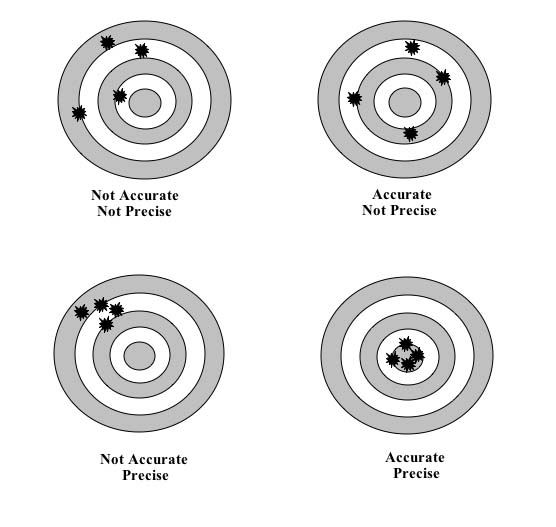
What it means is that the exact distance may be out by 25mm, but the precision is to the nearest mm. In other words, if the distance is x, then it can detect a change in that reading from year to year to the nearest mm.  When you have a systematic error, the precision can be improved by taking a larger sample size. So, the different agencies report slightly different precisions.

GMSL Rates
CU: 3.2 ± 0.4 mm/yr
AVISO: 3.2 ± 0.6 mm/yr
CSIRO: 3.2 ± 0.4 mm/yr
NOAA: 3.2 ± 0.4 mm/yr (w/ GIA)


I'm sorry if I haven't been helpful in explaining this, but you were adopting a brick wall position. To take an example, let's say you have a 10 metre measuring pole that is monitoring the subsidence of a Highset building (Say a Queenslander). That ruler may have an accuracy of +/- 10mm, but the precision of the measurement might be +/- 1mm. So you can estimate the height to the ground floor with an accuracy of 10mm, but the precision of the measurement is to the nearest mm. So you can tell if the building is sinking by say 1mm per month, but you can't tell the height to the ground as accurately as that. 

Please tell me that you understand this.

Title: Re: Why satellites cannot measure sea level..??
Post by muso on Sep 21st, 2013 at 3:57pm
By the way, the factor that changes when electromagnetic radiation passes through a varying medium is the speed. Air has a refractive index of  about 1.0002. So the speed of light and other electromagnetic radiation is around 90km/ second slower in air compared to a vacuum.

The pathway itself doesn't change the frequency or wavelength.  What does change the frequency of the received radiation is the motion of the satellite itself. That's called the Doppler effect, and that's taken into account.

You must have come across the terms red shift or blue shift.

Title: Re: Why satellites cannot measure sea level..??
Post by Ajax on Sep 22nd, 2013 at 10:34am

muso wrote on Sep 21st, 2013 at 3:40pm:
What it means is that the exact distance may be out by 25mm, but the precision is to the nearest mm. In other words, if the distance is x, then it can detect a change in that reading from year to year to the nearest mm.  When you have a systematic error, the precision can be improved by taking a larger sample size. So, the different agencies report slightly different precisions.

GMSL Rates
CU: 3.2 ± 0.4 mm/yr
AVISO: 3.2 ± 0.6 mm/yr
CSIRO: 3.2 ± 0.4 mm/yr
NOAA: 3.2 ± 0.4 mm/yr (w/ GIA)


I'm sorry if I haven't been helpful in explaining this, but you were adopting a brick wall position. To take an example, let's say you have a 10 metre measuring pole that is monitoring the subsidence of a Highset building (Say a Queenslander). That ruler may have an accuracy of +/- 10mm, but the precision of the measurement might be +/- 1mm. So you can estimate the height to the ground floor with an accuracy of 10mm, but the precision of the measurement is to the nearest mm. So you can tell if the building is sinking by say 1mm per month, but you can't tell the height to the ground as accurately as that. 

Please tell me that you understand this.


I'm not being a smart asre here but genuine.

The statements in your post about accuracy can they be for the ideal condition....???

Where nothing interferes with the signal.......????

Because when I look up the accuracy of altimeters, most of the information says that they can only read to an accuracy of about one to two centimetres due to interference factors.

Have a squiz here.

http://www.altimetry.info/html/alti/principle/waveform/welcome_en.html

http://www.altimetry.info/html/alti/dataflow/processing/pod/welcome_en.html

http://www.altimetry.info/html/appli/hydro/welcome_en.html

Personally I find it hard to believe that they could measure with an accuracy of one millimetre.

Especially when they say that they can track the satellite position in space to within a few centimetres.

And

The frequency is affected by the atmosphere to some extent.

I could believe 10mm to 20mm but 1mm I have a hard time believing that.

That's just me I suppose, I always doubt things until it can be proven.

Title: Re: Why satellites cannot measure sea level..??
Post by muso on Sep 22nd, 2013 at 10:42am
Ajax, read my last post again, and particularly the example on the house subsidence. Do you understand the difference between accuracy and precision? I don't think you've twigged yet.

After they launched Jason 2, there was a period where they compared data against Jason 1.  The measurements were adjusted for the systematic error over that period.

Read the post over. It will twig eventually.


Quote:
The statements in your post about accuracy can they be for the ideal condition....???

Where nothing interferes with the signal.......????


(First of all precision, not accuracy is important here. )

No. During a severe solar storm, there are no measurements. Moisture in the air path is corrected for. There are no ideal conditions.

Let me know when you understand so we can move on.

Title: Re: Why satellites cannot measure sea level..??
Post by Ajax on Sep 22nd, 2013 at 11:02am
I think we are going to have to agree to disagree on this one.

I've taken in what you've said and what articles that I have found say.

I'm still not convinced that satellites can read with an accuracy of 1mm.


Quote:
1.7. Coastal applications

Many current studies are attempting to enhance the quality of altimetry data close to the coasts. New processing methods and applications can then be developed for littoral and shallow-water regions, some of the most fragile and important areas of the oceans.

The shortage of altimetry data near the coasts (or their inferior quality) is due to several factors:
   - the technique itself, since the radar echoes reflected off water, and off a combination of water and land are not identical, and basically only the former undergo processing by the ground segments. Other altimetry satellite measurements also suffer from the same problem, such as those from the radiometer (at a distance of about 50 km from the coast)
   - - the fact that the basic distributed data (GDR) are mainly average over one second, thus covering about 7 km on the ground (data averaged over 1/20 s do exist, however).
   - the computation of some corrections. Tides, in particular, are much more complex near the shores than in the open sea, and require a highly precise knowledge of the coastal geography to be accurately computed. Moreover, rapid variations ("high frequency") must be taken into account in those areas (for the tides as well as for the atmospheric pressure). Wet tropospheric corrections, computed from radiometer measurements are also less precise, or even missing, near the coasts.

http://www.altimetry.info/html/appli/coastal/welcome_en.html


Title: Re: Why satellites cannot measure sea level..??
Post by muso on Sep 22nd, 2013 at 11:30am

Ajax wrote on Sep 22nd, 2013 at 11:02am:
I think we are going to have to agree to disagree on this one.

I've taken in what you've said and what articles that I have found say.

I'm still not convinced that satellites can read with an accuracy of 1mm.


Not accuracy, precision! a precision of 1mm. Read my post again. An accuracy of 25mm and a precision of 1mm.

Am I not explaining this well enough?

Title: Re: Why satellites cannot measure sea level..??
Post by Ajax on Sep 22nd, 2013 at 11:39am

muso wrote on Sep 22nd, 2013 at 11:30am:

Ajax wrote on Sep 22nd, 2013 at 11:02am:
I think we are going to have to agree to disagree on this one.

I've taken in what you've said and what articles that I have found say.

I'm still not convinced that satellites can read with an accuracy of 1mm.


Not accuracy, precision! a precision of 1mm. Read my post again. An accuracy of 25mm and a precision of 1mm.

Am I not explaining this well enough?


Are you saying that the accuracy can be 25mm plus or minus a millimetre......????????

In which case it would be impossible to measure the 7mm drop in sea levels in the year 2011.....!!!!

Title: Re: Why satellites cannot measure sea level..??
Post by muso on Sep 22nd, 2013 at 12:24pm
No. You don't understand precision. Let me think about how to explain this to you best. Here, I'll let somebody else explain.

http://celebrating200years.noaa.gov/magazine/tct/tct_side1.html


Quote:
To illustrate the distinction between terms using a surveying example, imagine surveyors very carefully measuring the distance between two survey points about 30 meters (approximately 100 feet) apart 10 times with a measuring tape.  All 10 of the results agree with each other to within two millimeters (less than one-tenth of an inch).  These would be very precise measurements.  However, suppose the tape they used was too long by 10 millimeters.  Then the measurements, even though very precise, would not be accurate.  Other factors that could affect the accuracy or precision of tape measurements include:  incorrect spacing of the marks on the tape, use of the tape at a temperature different from the temperature at which it was calibrated, and use of the tape without the correct tension to control the amount of sag in the tape.


If you were conducting a study on the gradual increase in Global Ocean Level, which would be most useful to you? Accuracy or precision?

What about if your study is on the absolute sea level. Accuracy or precision?

Title: Re: Why satellites cannot measure sea level..??
Post by Ajax on Sep 24th, 2013 at 5:43pm

muso wrote on Sep 22nd, 2013 at 12:24pm:
If you were conducting a study on the gradual increase in Global Ocean Level, which would be most useful to you? Accuracy or precision?

What about if your study is on the absolute sea level. Accuracy or precision?


Both would be necessary otherwise you're claim would be subjected to criticism....!!

This will depend upon the instruments you're using and how your measurements stack up against other methods that measure the same thing.

So let me ask you a question.......???????

The information you posted says that the accuracy can be within plus or minus 25mm.

Making the overall drift or error margin 50mm....!!!!!

So then if all your measurements taken with the satellite fall within 50mm range or mark.

Are these deemed to be precise...............???????

Precision is 50mm +- 1mm.


Title: Re: Why satellites cannot measure sea level..??
Post by muso on Sep 24th, 2013 at 6:58pm
Off-Topic replies have been moved to this Topic.

Title: Re: Why satellites cannot measure sea level..??
Post by muso on Sep 24th, 2013 at 7:10pm

Ajax wrote on Sep 24th, 2013 at 5:43pm:

muso wrote on Sep 22nd, 2013 at 12:24pm:
If you were conducting a study on the gradual increase in Global Ocean Level, which would be most useful to you? Accuracy or precision?

What about if your study is on the absolute sea level. Accuracy or precision?


Both would be necessary otherwise you're claim would be subjected to criticism....!!

This will depend upon the instruments you're using and how your measurements stack up against other methods that measure the same thing.


So then if all your measurements taken with the satellite fall within 50mm range or mark.

Are these deemed to be precise...............???????

Precision is 50mm +- 1mm.


You still haven't got it.


Quote:
[quote]
If you were conducting a study on the gradual increase in Global Ocean Level, which would be most useful to you? Accuracy or precision?
(Precision)

What about if your study is on the absolute sea level. Accuracy or precision?Accuracy


Both would be necessary otherwise you're claim would be subjected to criticism....!![/quote]

I gave you the answers. Have a look at them and see if you understand.


Quote:
So let me ask you a question.......???????

The information you posted says that the accuracy can be within plus or minus 25mm.

Making the overall drift or error margin 50mm....!!!!!


Error margin (accuracy of absolute distance) and drift are totally different things. 

The drift is less than 1mm.  I already gave you that. The stability is better than 1mm. That's the precision.

Now I'll attempt to explain again. We don't know the distance accurately, but the measurement that we get is stable to 1mm.  So it doesn't matter the fact that the distance may have a systematic error of +/- 25mm,  what matters is that we can tell the difference between readings with a precision better than 1mm. In fact it's 0.4mm or 0.6mm depending on the agency.

Ajax, Please read this example again


Quote:
To illustrate the distinction between terms using a surveying example, imagine surveyors very carefully measuring the distance between two survey points about 30 meters (approximately 100 feet) apart 10 times with a measuring tape.  All 10 of the results agree with each other to within two millimeters (less than one-tenth of an inch).  These would be very precise measurements.  However, suppose the tape they used was too long by 10 millimeters.  Then the measurements, even though very precise, would not be accurate.  Other factors that could affect the accuracy or precision of tape measurements include:  incorrect spacing of the marks on the tape, use of the tape at a temperature different from the temperature at which it was calibrated, and use of the tape without the correct tension to control the amount of sag in the tape.


Let me know when you get it. I'm sure that you'll kick yourself when you finally do.

Title: Re: Why satellites cannot measure sea level..??
Post by muso on Sep 25th, 2013 at 8:04am
If you're measuring an altitude, the actual figure you get may be off by =/- 25mm. OK?

However the stability or precision of that reading is better than 1mm.

Let's take some hypothetical readings in mm. The dotted lines represent the other digits of a very large number. In each case, that number is the same. I know that this is not literally correct, but I'm just trying to convey the concept of precision.

..................156.7 mm
..................156.3 mm
..................156.5 mm
..................156.2 mm
..................156.5 mm
..................156.4 mm
..................156.6 mm
..................156.7 mm
..................156.3 mm
..................156.5 mm

OK, you can see that it's a stable reading, but the absolute value could be out as much as 25mm either side.

If you are measuring the change in value from year to year, then that absolute value doesn't matter. You can still measure the change from year to year with a confidence of better than 1mm.

That's what's meant by precision.

Title: Re: Why satellites cannot measure sea level..??
Post by Ajax on Sep 25th, 2013 at 8:38pm

muso wrote on Sep 25th, 2013 at 8:04am:
If you're measuring an altitude, the actual figure you get may be off by =/- 25mm. OK?

However the stability or precision of that reading is better than 1mm.

Let's take some hypothetical readings in mm. The dotted lines represent the other digits of a very large number. In each case, that number is the same. I know that this is not literally correct, but I'm just trying to convey the concept of precision.

..................156.7 mm
..................156.3 mm
..................156.5 mm
..................156.2 mm
..................156.5 mm
..................156.4 mm
..................156.6 mm
..................156.7 mm
..................156.3 mm
..................156.5 mm

OK, you can see that it's a stable reading, but the absolute value could be out as much as 25mm either side.

If you are measuring the change in value from year to year, then that absolute value doesn't matter. You can still measure the change from year to year with a confidence of better than 1mm.

That's what's meant by precision.


Thank God we have engineers to build things......??????

Title: Re: Why satellites cannot measure sea level..??
Post by muso on Sep 25th, 2013 at 8:48pm
Ajax, I've come to the conclusion that you are totally incapable of understanding very basic concepts. You go on believing exactly what you want to believe.

It is of course faith based, because you lack any basic ability to understand the difference between science and mythology.  You are easily conned by shallow arguments, and even if the fallacies and underlying fallacious methodologies are demonstrated, you continue to believe.

You are one of the true faithful.

Ego te absolvo.

Title: Re: Why satellites cannot measure sea level..??
Post by Ajax on Sep 25th, 2013 at 8:53pm

muso wrote on Sep 25th, 2013 at 8:48pm:
Ajax, I've come to the conclusion that you are totally incapable of understanding very basic concepts. You go on believing exactly what you want to believe.

It is of course faith based, because you lack any basic ability to understand the difference between science and mythology.  You are easily conned by shallow arguments, and even if the fallacies and underlying fallacious methodologies are demonstrated, you continue to believe.

You are one of the true faithful.

Ego te absolvo.


Dude when you tell me that a measurement eg. 156.7mm can have an accuracy of +-25mm (50mm drift).

Then tell me that the precision of that next few measurements can be within +-1mm of the original measurement 156.7mm.

I say thank God we have engineers to build things....!!!!!

Title: Re: Why satellites cannot measure sea level..??
Post by muso on Sep 25th, 2013 at 9:02pm

Ajax wrote on Sep 25th, 2013 at 8:53pm:

muso wrote on Sep 25th, 2013 at 8:48pm:
Ajax, I've come to the conclusion that you are totally incapable of understanding very basic concepts. You go on believing exactly what you want to believe.

It is of course faith based, because you lack any basic ability to understand the difference between science and mythology.  You are easily conned by shallow arguments, and even if the fallacies and underlying fallacious methodologies are demonstrated, you continue to believe.

You are one of the true faithful.

Ego te absolvo.


Dude when you tell me that a measurement eg. 156.7mm can have an accuracy of +-25mm (50mm drift).


Are you totally thick? The drift (precision) is 1mm. Accuracy and Precision are totally different things.

Title: Re: Why satellites cannot measure sea level..??
Post by Ajax on Sep 25th, 2013 at 9:09pm

muso wrote on Sep 25th, 2013 at 9:02pm:
Are you totally thick? The drift (precision) is 1mm. Accuracy and Precision are totally different things.


Ditto my previous post.......!!!!!!


Quote:
Dude when you tell me that a measurement eg. 156.7mm can have an accuracy of +-25mm (50mm drift).

Then tell me that the precision of that next few measurements can be within +-1mm of the original measurement 156.7mm.

I say thank God we have engineers to build things....!!!!!

Title: Re: Why satellites cannot measure sea level..??
Post by muso on Sep 25th, 2013 at 9:50pm
OK, one last attempt. I have a hiking GPS. It's not particularly accurate, unless you calibrate it at mean sea level, but it's very precise.

When I'm climbing, I can see that I have ascended say 501 metres, but the absolute altitude is not accurate to 1 metre. It's precise enough to show that I have ascended even 1 metre, but it might only be accurate to 25 metres absolute.

In other words, when I'm measuring the difference in altitude, the figure is quite reliable but the absolute altitude may be off. 

Many scientific instruments have that issue - high precision but lower accuracy. Satellite altimetry is just one example of that.

Do you understand now?   

Title: Re: Why satellites cannot measure sea level..??
Post by Ajax on Sep 26th, 2013 at 12:12pm

muso wrote on Sep 25th, 2013 at 9:50pm:
OK, one last attempt. I have a hiking GPS. It's not particularly accurate, unless you calibrate it at mean sea level, but it's very precise.

When I'm climbing, I can see that I have ascended say 501 metres, but the absolute altitude is not accurate to 1 metre. It's precise enough to show that I have ascended even 1 metre, but it might only be accurate to 25 metres absolute.

In other words, when I'm measuring the difference in altitude, the figure is quite reliable but the absolute altitude may be off. 

Many scientific instruments have that issue - high precision but lower accuracy. Satellite altimetry is just one example of that.

Do you understand now?   


你傻

Nǐ shǎ


Quote:
Abstract—The unprecedented accuracy of elevations retrieved

from the Ice Cloud and Land Elevation Satellite (ICESat) laser

altimeter is investigated and used to characterize the range errors

in the Environmental Satellite (Envisat) and European Remote

Sensing 2 Satellite (ERS-2) radar altimeters over the continental

ice sheets. Cross-mission crossover analysis between time-coincident

ERS-2-, Envisat-, and ICESat-retrieved elevations and comparisons

to an ICESat-derived digital elevation map are used to
quantify the radar elevation error budget as a function of surface

slope and to investigate the effectiveness of a method to account

for the radar altimeter slope-induced error. The precision and

accuracy of the elevations retrieved from the ICESat Geoscience

Laser Altimeter System and the European Space Agency radar

altimeters on ERS-2 and Envisat are calculated over the Greenland

and Antarctic ice sheets using a crossover analysis. As a result

of this work, the laser precision is found to vary as a function of

surface slope from 14 to 59 cm, and the radar precision varies

from 59 cm to 3.7 m for ERS-2 and from 28 cm to 2.06 m for

Envisat. Envisat elevation retrievals when compared with ICESat

results over regions with less than 0.1◦ surface slopes show a mean

difference of 9 ± 5 cm for Greenland and −40 ± 98 cm over
Antarctica. ERS-2 elevation retrievals over these same low surface

slope regions differ from ICESat results by −56 ± 72 cm over

Greenland and 1.12 ± 1.16 m over Antarctica. At higher surface

slopes of 0.7◦ to 0.8◦, the Envisat/ICESat differences increase

to −2.27 ± 23 m over Greenland and to 0.05 ± 26 m over
Antarctica.

http://icesat.gsfc.nasa.gov/icesat/publications/pubs/Brenner-Precision_and_Accuracy_of_Satellite_Radar.pdf

Title: Re: Why satellites cannot measure sea level..??
Post by muso on Sep 26th, 2013 at 12:43pm
Careful with the personal insults. 你不聰明

ICEsat has a totally different configuration to Jason-2.

Title: Re: Why satellites cannot measure sea level..??
Post by Ajax on Sep 26th, 2013 at 4:31pm

muso wrote on Sep 26th, 2013 at 12:43pm:
Careful with the personal insults. 你不聰明


it means "your silly" I think.... :D


Quote:
ICEsat has a totally different configuration to Jason-2.


but the enigma of accuracy and precision still persists...!!!

Title: Re: Why satellites cannot measure sea level..??
Post by muso on Sep 26th, 2013 at 10:22pm

Ajax wrote on Sep 26th, 2013 at 4:31pm:

muso wrote on Sep 26th, 2013 at 12:43pm:
Careful with the personal insults. 你不聰明


it means "your silly" I think.... :D


Quote:
ICEsat has a totally different configuration to Jason-2.


but the enigma of accuracy and precision still persists...!!!


When you finally understand the concepts, let me know.

Yours said "You're stupid". Mine said "You're not too smart", but I speak Chinese better than I read it.


Title: Re: Why satellites cannot measure sea level..??
Post by Ajax on Sep 27th, 2013 at 9:27am
I understand the concept, and  like I said thank God engineers build things.

Title: Re: Why satellites cannot measure sea level..??
Post by muso on Sep 27th, 2013 at 10:12am
With an altimeter reading having an accuracy of +/- 25mm and a precision of better than +/- 1mm, what is the drift in the reading?

Title: Re: Why satellites cannot measure sea level..??
Post by Ajax on Sep 27th, 2013 at 10:37am

muso wrote on Sep 27th, 2013 at 10:12am:
With an altimeter reading having an accuracy of +/- 25mm and a precision of better than +/- 1mm, what is the drift in the reading?


Like I keep saying, thank God engineers and not scientists build things.


Quote:
Accuracy

Accuracy and precision have very different meanings.

The average value of many readings taken with an accurate instrument will be close to the true value of the quantity being measured.

(If the instrument is not very precise, many repeated measurements will have to be made to reduce the uncertainty in the average value, whereas a precise and accurate instrument requires few repeated measurements to obtain a good measurement.)

Conversely, an inaccurate instrument is one which produces measurements whose average value is not the true value.

A famous example of the difference between precision and accuracy (and the influence of human nature in science) occurred a few years ago with the Hubble space telescope.

The manufacturers of the concave mirror for the telescope used a machine that could very precisely cut the glass so that its radius of curvature was known precisely to about 0.5 µm (0.0005 mm).

An astronomer who was going to be using the telescope soon after it was launched into orbit offered to confirm the measurement by using a much simpler technique that was not as precise as the instruments used by the manufacturer.

The manufacturers told him to stop worrying, and that their instruments were far more precise than the astronomer's simple equipment.

The telescope was launched into orbit, and as you may remember the images were fuzzy, very fuzzy ... in fact much worse than telescopes on earth. When the mirror manufacturers were asked to check their equipment, they found that they had forgot to include a certain spacer that added 2 mm to the measurement of the radius of curvature.

They had manufactured a radius of curvature that was precise to 0.5 µm but was inaccurate by 2 mm. The repercussions of this little "mistake" were enormous - NASA had a substantial amount of egg on its face, and, more to the point, the cost of correcting the telescope was enormous in terms of money (millions of dollars) and lost time.

The correction was achieved by inserting a corrective lens into the telescope, which sharpened the image but unfortunately meant that it could never be quite as good as was originally hoped.

http://www.patana.ac.th/secondary/science/anrophysics/ntopic1/resources/accuracy%20and%20precision.htm


High Accuracy, High Precision


High Accuracy, Low Precision


Low Accuracy, High Precision

Title: Re: Why satellites cannot measure sea level..??
Post by muso on Sep 27th, 2013 at 11:39am

Ajax wrote on Sep 27th, 2013 at 10:37am:

muso wrote on Sep 27th, 2013 at 10:12am:
With an altimeter reading having an accuracy of +/- 25mm and a precision of better than +/- 1mm, what is the drift in the reading?


Like I keep saying, thank God engineers and not scientists build things.


Answer the question. If you prefer, how stable is the reading?

Title: Re: Why satellites cannot measure sea level..??
Post by Ajax on Sep 27th, 2013 at 11:59am

muso wrote on Sep 27th, 2013 at 11:39am:

Ajax wrote on Sep 27th, 2013 at 10:37am:

muso wrote on Sep 27th, 2013 at 10:12am:
With an altimeter reading having an accuracy of +/- 25mm and a precision of better than +/- 1mm, what is the drift in the reading?


Like I keep saying, thank God engineers and not scientists build things.


Answer the question. If you prefer, how stable is the reading?


The accuracy can be within a 50mm radius bullseye, +-25mm either way of dead centre.

The precision of the readings can be within +-1mm of each other.


Title: Re: Why satellites cannot measure sea level..??
Post by muso on Sep 27th, 2013 at 12:18pm

Ajax wrote on Sep 27th, 2013 at 11:59am:

muso wrote on Sep 27th, 2013 at 11:39am:

Ajax wrote on Sep 27th, 2013 at 10:37am:

muso wrote on Sep 27th, 2013 at 10:12am:
With an altimeter reading having an accuracy of +/- 25mm and a precision of better than +/- 1mm, what is the drift in the reading?


Like I keep saying, thank God engineers and not scientists build things.


Answer the question. If you prefer, how stable is the reading?


The accuracy can be within a 50mm radius bullseye, +-25mm either way of dead centre.

The precision of the readings can be within +-1mm of each other.


Good. So now you understand that when measuring the rate of change of sea level rise, the result will be better than 1mm.

There are a lot of provisos there of course. You're talking about the composite of every single reading over each year.

High precision, low accuracy is a common theme when measuring altitude.

Another example is aircraft altimeters. There are two types. One uses baromateric pressure and the other uses radar.

Regular calibration is needed to maintain accuracy, whereas precision is not affected.  Many aircraft crashes have been caused by the altimeter being set incorrectly. The rate of descent is indicated quite precisely but the accuracy of the altitude is off.

When Jason 3 is launched next year, there will be a period where the readings are compared against Jason 2 to ensure that the accuracy is good, otherwise there will be a step change, like the ACRIM gap in the TSI satellites.

Can you also see why Willy Soon as an Astrophysics expert, should have known that?

Title: Re: Why satellites cannot measure sea level..??
Post by Ajax on Sep 27th, 2013 at 12:30pm
The bottom line is the accuracy for one reading can be within +-25mm or a 50mm drift or error margin..call it what you will....!!!

The next reading and the reading after that will be within +-1mm within the area of where the preceding reading was taken from.......or within the general vicinity....!!!!

Title: Re: Why satellites cannot measure sea level..??
Post by muso on Sep 27th, 2013 at 5:31pm

Ajax wrote on Sep 27th, 2013 at 12:30pm:
The bottom line is the accuracy for one reading can be within +-25mm or a 50mm drift or error margin..call it what you will....!!!

The next reading and the reading after that will be within +-1mm within the area of where the preceding reading was taken from.......or within the general vicinity....!!!!


+/- 25mm systematic error. Drift is the wrong term. This systematic error could be due to any number of factors, but the main thing is that we don't need the exact measurement. It just has to be stable.

The technical data quotes a precision of better than 1mm per annum.

Why do you think Willie Soon lied about it? Wouldn't you think that an astrophysict would be able to check out those details quite easily?

Title: Re: Why satellites cannot measure sea level..??
Post by Ajax on Sep 30th, 2013 at 9:17am

muso wrote on Sep 27th, 2013 at 5:31pm:
+/- 25mm systematic error. Drift is the wrong term. This systematic error could be due to any number of factors, but the main thing is that we don't need the exact measurement. It just has to be stable.


WTF are you talking about muso, its clear that the best satellites have an accuracy of +-25mm, giving them an error margin of 50mm.

Its black and white why are you trying to fudge the facts..???


Quote:
The technical data quotes a precision of better than 1mm per annum.


So what if the microwave beam can be fired within +-1mm of where the previous beam was fired......??????

The accuracy is still +-25mm or a 50mm drift.

If the first beam can land within the vicinity of the previous beam with a precision of +-1mm this doesn't mean that the accuracy of actually measuring the sea level is any better than +-25mm.


Quote:
Why do you think Willie Soon lied about it? Wouldn't you think that an astrophysict would be able to check out those details quite easily?


Maybe he wasn't talking about Jason....??????

Now stop telling me that the precision is better than 1mm.

This is not the accuracy....!!!!

The accuracy of the reading has +-25mm error margin.

The beam can be fired in the same vicinity to within 1mm of each other.

Title: Re: Why satellites cannot measure sea level..??
Post by muso on Sep 30th, 2013 at 5:56pm
I thought you understood, but I don't think that you're capable of it you do.

I think the problem is that you don't understand the concept of "systematic error". If there is an inherent precision of 1mm per annum, then an error of 25mm is by implication systematic in nature. In other words the error stays the same plus or minus 1mm.

Think millions of measurements over a year. The precision applies to the average or mean value.


Quote:
Maybe he wasn't talking about Jason....?


I'm less charitable - Willy Soon is lying through his teeth.  Jason 2 is the only satellite designed for that purpose.

Title: Re: Why satellites cannot measure sea level..??
Post by Ajax on Oct 1st, 2013 at 1:46pm

muso wrote on Sep 30th, 2013 at 5:56pm:
I thought you understood, but I don't think that you're capable of it you do.

I think the problem is that you don't understand the concept of "systematic error". If there is an inherent precision of 1mm per annum, then an error of 25mm is by implication systematic in nature. In other words the error stays the same plus or minus 1mm.


I understand perfectly thank you very much.

The accuracy of the microwave beam is +-25mm....(50mm error margin).

The precision with which the microwave beam can fired in the near vicinity of the previous measurement is within +-1mm.

There's nothing more to say, its black and white....????

Title: Re: Why satellites cannot measure sea level..??
Post by muso on Oct 1st, 2013 at 5:11pm

Ajax wrote on Oct 1st, 2013 at 1:46pm:

muso wrote on Sep 30th, 2013 at 5:56pm:
I thought you understood, but I don't think that you're capable of it you do.

I think the problem is that you don't understand the concept of "systematic error". If there is an inherent precision of 1mm per annum, then an error of 25mm is by implication systematic in nature. In other words the error stays the same plus or minus 1mm.


I understand perfectly thank you very much.

The accuracy of the microwave beam is +-25mm....(50mm error margin).

The precision with which the microwave beam can fired in the near vicinity of the previous measurement is within +-1mm.

There's nothing more to say, its black and white....????


As long as you realise that the "previous measurement" was the previous year in this context.

Title: Re: Why satellites cannot measure sea level..??
Post by Ajax on Oct 4th, 2013 at 11:04am

muso wrote on Oct 1st, 2013 at 5:11pm:

Ajax wrote on Oct 1st, 2013 at 1:46pm:

muso wrote on Sep 30th, 2013 at 5:56pm:
I thought you understood, but I don't think that you're capable of it you do.

I think the problem is that you don't understand the concept of "systematic error". If there is an inherent precision of 1mm per annum, then an error of 25mm is by implication systematic in nature. In other words the error stays the same plus or minus 1mm.


I understand perfectly thank you very much.

The accuracy of the microwave beam is +-25mm....(50mm error margin).

The precision with which the microwave beam can fired in the near vicinity of the previous measurement is within +-1mm.

There's nothing more to say, its black and white....????


As long as you realise that the "previous measurement" was the previous year in this context.


YeeHaa

http://youtu.be/XARrwOHjs2g

Australian Politics Forum » Powered by YaBB 2.5.2!
YaBB Forum Software © 2000-2025. All Rights Reserved.