Australian Politics Forum
http://www.ozpolitic.com/forum/YaBB.pl
Member Run Boards >> Cats and Critters >> Troposphere warming and stratosphere cooling
http://www.ozpolitic.com/forum/YaBB.pl?num=1682660229

Message started by Jovial Monk on Apr 28th, 2023 at 3:37pm

Title: Troposphere warming and stratosphere cooling
Post by Jovial Monk on Apr 28th, 2023 at 3:37pm

Quote:
Radio occultation data show that in the first two decades of the 21st century, the Earth’s lowest atmospheric layer – the troposphere – warmed significantly, by up to 0.5 K per decade, while the layer above that – the stratosphere - cooled by about the same amount.


That is a big difference. The troposphere is not the surface—it is the part of the atmosphere above the surface but below the stratosphere. Emission of IR is directly proportional to temperature—the cooler the less IR is emitted. The IR that reaches space is emitted from the top of the atmosphere—and that, as we see above, is cooling!


Quote:
Over the last century, the amount of greenhouse gases has accumulated in the Earth’s atmosphere at a gradually accelerating rate. It is expected that the warming caused by greenhouse gases impacts the structure of Earth's atmosphere (Meng et al., 2021). This is precisely what we observe. During the past decades the atmospheric layer closest to the Earth surface, the troposphere, has warmed, while the layer above it, the stratosphere, has cooled (see Figure 1), and related to these changes, the tropopause height has risen globally (IPCC, 2021).


Tropopause:

Quote:
Definition

The atmosphere of planet Earth: The tropopause is between the troposphere and the stratosphere.
Rising from the planetary surface of the Earth, the tropopause is the atmospheric level where the air ceases to become cool with increased altitude and becomes dry, devoid of water vapor. The tropopause is the boundary that demarcates the troposphere below from the stratosphere above, and is part of the atmosphere where there occurs an abrupt change in the environmental lapse rate (ELR) of temperature, from a positive rate (of decrease) in the troposphere to a negative rate in the stratosphere. The tropopause is defined as the lowest level at which the lapse rate decreases to 2°C/km or less, provided that the average lapse-rate, between that level and all other higher levels within 2.0 km does not exceed 2°C/km.[1] The tropopause is a first-order discontinuity surface, in which temperature as a function of height varies continuously through the atmosphere, while the temperature gradient has a discontinuity.


(wiki)


Quote:
Quantifying the rate of warming and cooling in the different layers of the free atmosphere is a difficult task, as evidenced by the low confidence the Intergovernmental Panel on Climate Change (IPCC) assigned, in its fifth assessment report, to the temperature changes in the free atmo­sphere (IPCC, 2013). However, in its sixth assessment report IPCC saw an improved confidence assigned to these temperature changes, in particular for the period after 2001 (IPCC, 2021). This is largely due to the addition of a new satellite-based data record, i.e. the Global Navigation Satellite System (GNSS) Radio Occultation (RO) data.

Since around the 1850s, the temperatures in the lowest layers of the troposphere have been measured with ground-based thermo­meters. However, these time series are quite uncertain in the earliest decades, and only provide measurements close to the surface. Apart from sparse balloon-borne measurements gathered since the 1940s, getting a detailed view of upper-atmosphere temperatures had to wait for the start of the satellite era.

Since the end of the 1970s, satellite-borne instruments, flown in Earth's orbit, have been providing regular observations of upper-atmosphere temperatures. Currently, several satellite-based techniques exist to measure these temperatures. Most techniques are based on radiance measurements of the Earth’s atmosphere at infrared or microwave wavelengths, such as those derived from measurements from the IASI and AMSU-A instruments onboard Metop satellites.


The RSS and the crap, denier run UAH6 series.

A new technique is GNSS radio occultation:

Quote:
Atmospheric radio occultation
Atmospheric radio occultation relies on the detection of a change in a radio signal as it passes through a planet's atmosphere, i.e. as it is occulted by the atmosphere. When electromagnetic radiation passes through the atmosphere, it is refracted (or bent). The magnitude of the refraction depends on the gradient of refractivity normal to the path, which in turn depends on the density gradient. The effect is most pronounced when the radiation traverses a long atmospheric limb path. At radio frequencies the amount of bending cannot be measured directly; instead the bending can be calculated using the Doppler shift of the signal given the geometry of the emitter and receiver. The amount of bending can be related to the refractive index by using an Abel transform on the formula relating bending angle to refractivity. In the case of the neutral atmosphere (below the ionosphere) information on the atmosphere's temperature, pressure and water vapour content can be derived giving radio occultation data applications in meteorology.[1]


(wiki)


Quote:
At beginning of this millennium, a relatively new technique, called GNSS Radio Occultation, was introduced. This technique derives atmospheric temperature profiles from bending of GNSS signals caused by atmospheric refraction. The unique long-term stability of these profiles makes them excellently suited for studying changes in tropospheric and stratospheric temperatures over long time period.


cont’d

Title: Re: Troposphere warming and stratosphere cooling
Post by Jovial Monk on Apr 28th, 2023 at 3:58pm
cont'd from OP:


Quote:
Observing the atmosphere with RO
The principle of the GNSS-RO technique is based on measuring shifts in phase and amplitude of radio waves as they propagate through the atmosphere from a GNSS satellite — flown at an altitude around 20,000km — to a receiver onboard a polar orbiting satellite — flown at altitudes between 300 and 1,300km (Figure 2). From the perspective of the receiver, a GNSS satellite is seen to set or rise at the Earth’s limb. Receiving a GNSS radio signal over a time-span of about two minutes is enough to make an atmospheric scan from near surface to well above the neutral atmosphere (~100km). During such a scan, the amount of refraction — or bending — of the ray can be computed from the phase shifts, and the refractive index of the air as function of height can be deter­mined. In the upper air, where humidity is low, the refractive index is proportional to air density. Hence, from a single occultation event, a near-vertical profile of temperature, pressure, and density from the middle troposphere to the upper stratosphere can be retrieved.


That is useful information. It does not, however cover the lower troposphere or surface—where we live!

RO is not a panacea:

Quote:
Unlike infrared measurements, the RO measurements are not affected by clouds or land-sea differences. Moreover, the RO measurements have a unique long-term stability — the advantage of measuring time differences rather than radiances — and, thus, require no inter-calibration between satellites or instruments. The latter is an important characteristic for studies of the climate where calibration issues can be a limiting factor. The weaknesses of the RO technique include a limited horizontal resolution of a few hundred kilometers, reduced accuracy in the lower troposphere, in particular in the tropics, and that the quasi-random distribution of the profiles makes provision of uniformly gridded data somewhat complicated.


How different this is to the snake oil sellers! Snake oil sellers know they need to skedaddle out of a town etc before the total uselessness of the pablum they sell becomes widely known!


Quote:
Preparing RO data for climate studies

Today we have a continuous time-series of more than 20 years of RO measurements, that starts in 2001. These measurements were provided by operational, as well as research, missions. In 2006, the data numbers increased dramatically, first with the launch of the COSMIC Taiwan-United States six-satellite mission, and later, with the launch of EUMETSAT’s Metop satellites that carry the GRAS RO instrument (Figure 3). Currently, these, and other missions operating RO instruments, have provided around 20 million atmospheric profiles that can be used to construct time series for climate applications.


The profiles:


Quote:
Daily number of observed atmospheric profiles in version 1 of the ROM SAF CDR and Interim CDR. Data from four RO satellite missions were included in the data records: CHAMP, GRACE, COSMIC, and Metop. The Interim CDR is presently updated regularly with a lag of about one month.


Quote:
RO data from GPS receivers operated onboard the CHAMP, GRACE, COSMIC, and Metop missions. The data are provided as four single-mission data records, as well as one multi-mission data record (see data record details below in the section Data used). In the free atmosphere, above about 5–6km, these data records have an excellent stability in time that surpasses that of, eg current reanalysis data records (Gleisner et al., 2020).


Does lee know what reanalysis is? I doubt it, but we will let him read up about it in his own time.


Quote:
One factor that needs to be addressed for any satellite-based measurement technique is sampling issues related to the orbits of the satellites. For example, the Metop satellites are placed in sun-synchronous orbits and always pass the equator at the same local time, while other satellites (eg CHAMP, GRACE, COSMIC) slowly drift in local time. As a consequence of the evolution of the observing system, where old satellite missions are gradually replaced by new missions, the local-time coverage may change over time with consequences for observations of, eg the diurnal cycle in the atmosphere. This is handled by a correction for the impacts of sampling errors based on an estimation of those errors. Such sampling-error corrected data are provided as a part the ROM SAF gridded monthly-mean data, and is the preferred choice for studies of climate variability and trends (Gleisner et al., 2020).


Again, pointing out potential problems/errors in the data. This is science, not snake oil.


Quote:
An accurate description of climate variability and trends requires time-series that i) are long enough to minimise the effect of variations associated with the weather, the seasons, and any other types of quasi-periodic variability (eg the El Niño-Southern Oscillation (ENSO)), and ii) are long enough to reach the required long-term stability of the measurements. With 20 years of RO data of sufficient accuracy and stability, we are now in a position where RO data contributes to our understanding of the climate of the Earth’s atmosphere (Ringer and Healy, 2008; Gleisner et al., 2022).


cont’d

Title: Re: Troposphere warming and stratosphere cooling
Post by Jovial Monk on Apr 28th, 2023 at 4:17pm
Cont’d from above post.


Quote:
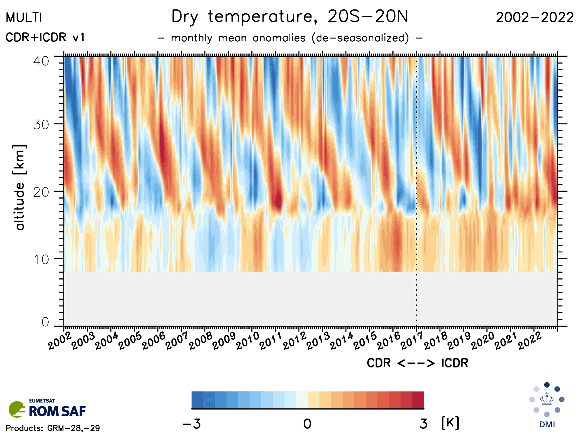
Figure 4 shows vertical distributions of monthly-mean temperature anomalies between 8km and 40km for the low-latitude region between 20°S and 20°N over the period 2002 to 2022. The title of the plot is dry temperature as an indication that the temperatures are retrieved under the assumption that the humidity is negligible. This is also why the lowest 8km is masked out. Sampling-error corrected data were selected from the data files, and we used the 10-year period 2007 to 2016 as reference for the anomaly calculations.


Fig4


Quote:
Figure 4:  Monthly mean temperature anomalies based on RO data from ROM SAF CDR and ICDR ver. 1, covering the period January 2002 to October 2022. Long-term trends in the data must be assessed against a background of other types of variability at different timescales.


Quote:
The figure clearly reveals a lot of structure in the temperature data. The height of the tropopause is seen as a relatively sharp boundary around 18km. Below about 18km, in the troposphere, the temperature anomalies exhibit variations associated with the ENSO and other modes of variability. ENSO is the most influential natural climate pattern on Earth, it refers to three to seven years repeating phases of warming (El Niño) and cooling (La Niña) sea surface temperatures across the tropical Pacific Ocean (NOAA, assessed 20 Jan 2023). Above about 18km, in the stratosphere, the temperature anomalies are dominated by the so called Quasi-Biennial Oscillation (QBO) — these are the regular oscillations in the equatorial stratosphere with an average period of ~28 months. Any long-term trend in the data must be detected against a background of variability at a range of different time scales, which is why the time series need to be sufficiently long.


Fig5


Quote:
Figure 5:  Decadal temperature trends over the period 2002 to 2022. The trends are computed from the gridded monthly mean RO data available in the ROM SAF CDR and ICDR version 1.


IPCC

Quote:
One set of findings of the RO contribution is summarised in Figure 6, which was included in Chapter 2 of the IPCC WG1 AR6 report (IPCC, 2021). It tells us that the observed warming rates are faster in the tropical upper troposphere than at, or near, the surface. Furthermore, the trends found in RO data agree reasonably well with the trends found in AIRS data and in radiosonde data, apart from a discrepancy between RO and radiosonde data around 15km. Steiner et al. (2020) suggests that this discrepancy is reduced to near zero if the radiosonde data is restricted to only high-quality instruments.


More about the IPCC and RO derived data:

Quote:
Another set of findings is presented in the Technical Summary of the IPCC WG1 AR6 report. In this summary the RO observed trends are related to two different climate modelled projections (see Figure 7). The similarities between the observations and the climate model projections are pointed out in in Chapter 2 of the IPCC WG1 AR6 report (IPCC, 2021) as follows:

In the tropics, since at least 2001 (when new techniques permit more robust quantification), the upper troposphere has warmed faster than the near-surface (medium confidence). There is medium confidence that most CMIP5 and CMIP6 models overestimate the observed warming in the upper tropical troposphere .

The conclusions from these assessments clearly show the potential of the RO climate data records to contribute to an improved understanding of the atmospheric changes associated with global warming.


https://www.eumetsat.int/tropospheric-warming-and-stratospheric-cooling-21st-century

Title: Re: Troposphere warming and stratosphere cooling
Post by Dnarever on Apr 28th, 2023 at 4:21pm
OH NO - you know what is going to happen here.

Title: Re: Troposphere warming and stratosphere cooling
Post by Jovial Monk on Apr 28th, 2023 at 4:31pm
lee is going to post a “refutation” of this paper? I can’t wait to see what that idiot comes up with! LOL!


It is SO nice I don’t have to respond to his idiocy.

Title: Re: Troposphere warming and stratosphere cooling
Post by Jovial Monk on Apr 28th, 2023 at 4:47pm
Booby is reading this thread and understanding 1% of it I reckon.

Title: Re: Troposphere warming and stratosphere cooling
Post by Jovial Monk on Apr 28th, 2023 at 4:50pm
Booby probably thinks this should be in his MRB. Tough titties—it was fine when you started the “Cats and Critters topics now here” in your toilet of a board, wasn’t it? You LOVED stealing videos I posted here or in the equivalent board in my fine forum.

You DON’T like the end result, do you, poof! What you think are environmental topics posted here. Tough—you started the off topic crap, now you cry. Awww!

Title: Re: Troposphere warming and stratosphere cooling
Post by Jovial Monk on Apr 28th, 2023 at 5:59pm
It seems the paper I quoted here was too sciency for poor old lee.  ;)

Water vapor gets a mention you old fraud!  ;D ;D ;D ;D ;D

Title: Re: Troposphere warming and stratosphere cooling
Post by Jovial Monk on Apr 30th, 2023 at 6:37am
And lee mixes up observations with model output.

Title: Re: Troposphere warming and stratosphere cooling
Post by UnSubRocky on Apr 30th, 2023 at 1:26pm

Jovial Monk wrote on Apr 30th, 2023 at 6:37am:
And lee mixes up observations with model output.


Are you and lee banned from each other's board?

Title: Re: Troposphere warming and stratosphere cooling
Post by Jovial Monk on Apr 30th, 2023 at 2:59pm
After I realised lee was arguing the same stupid point we had already argued three times I banned him from here. lee cannot abide change happening and AGW is change.

Title: Re: Troposphere warming and stratosphere cooling
Post by Jovial Monk on May 1st, 2023 at 6:33am

Jovial Monk wrote on Apr 30th, 2023 at 6:37am:
And lee mixes up observations with model output.


LOL! lee read this, does not understand, still mixes them up.

Title: Re: Troposphere warming and stratosphere cooling
Post by UnSubRocky on May 1st, 2023 at 8:59pm
Unban lee and let him back to debate you again on the topic. You are by yourself on this. I don't really care too much about the issue to respond much.

Title: Re: Troposphere warming and stratosphere cooling
Post by Jovial Monk on May 1st, 2023 at 9:08pm
You are joking! I made a post to introduce the topic of AGW, just an intro—lee came in arguing that AGW didn’t exist blah blah blah. Too damn tedious! He is afraid of change and AGW is change!


That was after the ridiculously inept GMods moved that topic to Environment but did NOT move the Cats and Critters videos from Environment to here! I recreated the post a couple of times, may have been given yet another pointless ban and recreated the post once more and the idiot GMods finally left it alone. I had forgotten by then some of the things I wanted to discuss how AGW is affecting critters. Now Off topic is all the rage. STUPID!

Title: Re: Troposphere warming and stratosphere cooling
Post by UnSubRocky on May 2nd, 2023 at 6:31pm
Obviously, I have not been paying attention to what you guys have been doing. Like I said in the environment forum, you guys seem more interesting in doing the "I am not talking to you" posts. So, keep at it like this.

Australian Politics Forum » Powered by YaBB 2.5.2!
YaBB Forum Software © 2000-2024. All Rights Reserved.